-
DJI ENTERPRISE, DJI PHANTOM, RTK/PPK
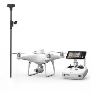
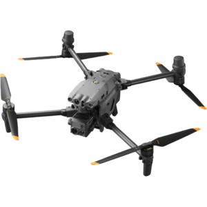
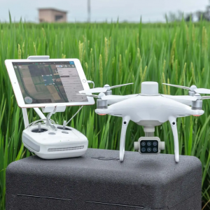
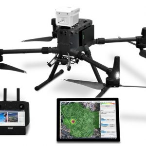
DJI Phantom 4 RTK Quadcopter with D-RTK 2 GNSS Mobile Station Combo
 DJI ENTERPRISE, DJI PHANTOM, RTK/PPK
DJI Phantom 4 RTK Quadcopter with D-RTK 2 GNSS Mobile Station Combo
- Enterprise-Level Drone Mapping Solution
- 1cm+1ppm RTK Horizontal Accuracy
- 1.5cm+1ppm RTK Vertical Accuracy
- Distortion Calibrated 1″ CMOS Sensor
- TimeSync Alignment for Accurate Metadata
- Controller with Display and GS RTK App
- Photogrammetry & Waypoint Flight Modes
- OcuSync for up to 4.3-Mile Streaming
- Up to 30 Minutes Flying Time
- D-RTK 2 GNSS Mobile Station Included
SKU: n/a -
DJI ZENMUSE XT, Z3, Z30, X7, X5, H, GIMBALS, CAMERAS, SENSORS
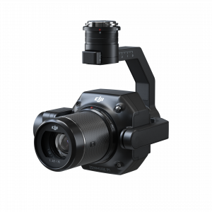
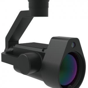
DJI Zenmuse P1
The Zenmuse P1 integrates a full-frame sensor with interchangeable fixed-focus lenses on a 3-axis stabilized gimbal. Designed for photogrammetry flight missions, it takes efficiency and accuracy to a whole new level.
SKU: n/a -
DJI ENTERPRISE, DJI ZENMUSE XT, Z3, Z30, X7, X5, H, GIMBALS, CAMERAS, SENSORS, LIDAR SYSTEMS
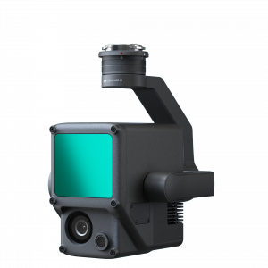
DJI Zenmuse L1 (LIDAR)
DJI ENTERPRISE, DJI ZENMUSE XT, Z3, Z30, X7, X5, H, GIMBALS, CAMERAS, SENSORS, LIDAR SYSTEMSDJI Zenmuse L1 (LIDAR)
The Zenmuse L1 integrates a Livox Lidar module, a high-accuracy IMU, and a camera with a 1-inch CMOS on a 3-axis stabilized gimbal. When used with Matrice 300 RTK and DJI Terra, the L1 forms a complete solution that gives you real-time 3D data throughout the day, efficiently capturing the details of complex structures and delivering highly accurate reconstructed models
SKU: n/a -
DJI ENTERPRISE, DJI MATRICE, DJI ZENMUSE XT, Z3, Z30, X7, X5, H, GIMBALS, CAMERAS, SENSORS
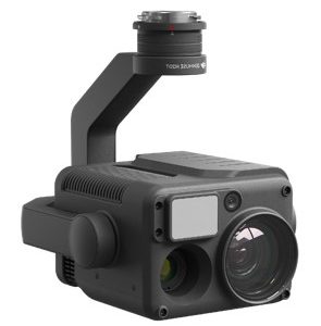
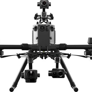
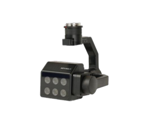
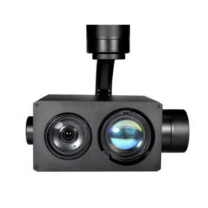
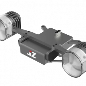
DJI Zenmuse H20T Quad-Sensor
 DJI ENTERPRISE, DJI MATRICE, DJI ZENMUSE XT, Z3, Z30, X7, X5, H, GIMBALS, CAMERAS, SENSORS
DJI Zenmuse H20T Quad-Sensor
Multi-sensor payloads that bring a whole new meaning to mission efficiency. The unique intelligence and integrated design provide unprecedented aerial imaging capabilities for a range of commercial drone applications.
IP44 Rating
-20°C to 50°C Operating Temperature
Night Scene Mode
Active Image Stabilization and EIS
12 MP Wide Camera
82.9° DFOV
20 MP Zoom Camera
23× Hybrid Optical Zoom
Laser Rangefinder 1200 m
640×512 px Radiometric Thermal CameraSKU: n/a -
-
-
Delair, PROFESSIONAL & INDUSTRIAL
Delair UX11 AG
THE SMARTEST PLANT-MAPPING DRONE
The Delair UX11 Ag is a plant-mapping drone capable of onboard data processing with wireless and 3G/4G communications. Thanks to its PPK-as-you-go feature it is possible to precisely overlay maps for temporal analysis and on the route planning and guidance for on the ground agricultural machines.Now you can collect plant aerial intelligence more accurately and efficiently and reach a new level of productivity.
SKU: n/a -
GIMBALS, CAMERAS, SENSORS, PAYLOADS SDK
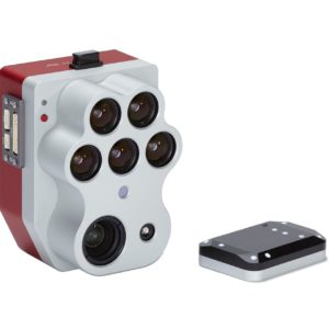
MS600 PRO Multispectral Camera
6band
Calibration correction
Real-time image transmission: data processing: support Yusense Map, Pix4D offline processing and “end-cloud integration”
Synchronous data upload
Storage/working temperature range: -30°C~+70°C/-10°C~+50°C
Environmental adaptability: sapphire window, scratch-resistant, abrasion-resistant and durableSKU: n/a -
DJI PHANTOM, GIMBALS, CAMERAS, SENSORS, RTK/PPK
DJI Phantom 4 Multispectral
The P4 Multispectral is a fully integrated multispectral imaging drone designed for precision agriculture and environmentalmanagement. Combining data from six separate sensors to measure the health of crops, from individual plants to entirefields, as well as weeds, insects and a variety of soil conditions, the P4 Multispectral sets a new standard for easy-to-useagricultural drone applications.SKU: n/a -
GIMBALS, CAMERAS, SENSORS, MICASENSE
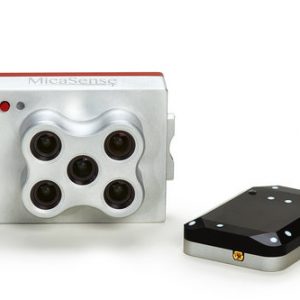
MICASENSE RedEdge MX
Professional Multispectral Sensor Kit
- New metal case for extreme durability
- New DLS 2 for enhanced light calibration
- Captures five narrow spectral bands
- Generates plant health indexes and RGB (color) images from one flight
- Designed for easy and flexible integration
- Calibrated for precise, repeatable measurements
- Operates in temperatures up to 60℃ or 140℉
Kit includes: RedEdge-MX, DLS 2 with embedded GPS, Calibrated Reflectance Panel, lens cover and hard carrying case.
SKU: n/a
-
DJI ZENMUSE XT, Z3, Z30, X7, X5, H, GIMBALS, CAMERAS, SENSORS
DJI Zenmuse P1
The Zenmuse P1 integrates a full-frame sensor with interchangeable fixed-focus lenses on a 3-axis stabilized gimbal. Designed for photogrammetry flight missions, it takes efficiency and accuracy to a whole new level.
SKU: n/a -
GIMBALS, CAMERAS, SENSORS, PAYLOADS SDK
Sniffer4d V2 Multi-gas Detection System
- Designed to be carried by drones & ground vehicles
- Captures georeferenced & timestamped gas & particle concentrations
- Real-time data transmission via LTE networks
- Multi-gas Detection Hardware
- Up to 9 Parameters at a Time
- Size 157 x 103 x 87mm
- Weight 400 – 500g
SKU: n/a -
GIMBALS, CAMERAS, SENSORS, PAYLOADS SDK
U10 LASER METHANE LEAKAGE DETECTOR
The U10 is a light-weight, high-sensitivity gas detector based on Tunable Diode Laser Absorption Spectroscopy (TDLAS), which enables rapid identification of methane from up to 100 m away, or at a concentration as low as 5ppm.m. Powered by DJI SkyPort, the U10 can be seamlessly integrated with DJI Matrice 200 Series V1 and V2 platforms.
SKU: n/a
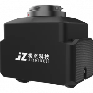
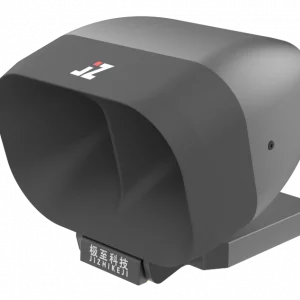
JZ Recommended
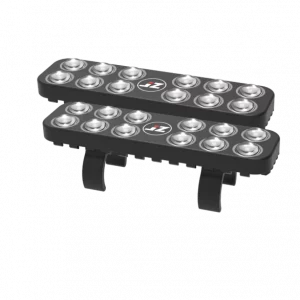
JZ S2 MATRIX FLASH
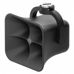
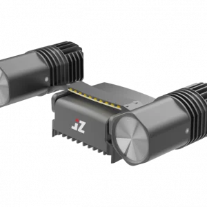
JZ T30S MATRIX LAMP
The JZ T30S MATRIX LAMP features a spotlight with a fully transparent front cover, upgrading the 4-piece lens group to 2 pieces, increasing light transmittance by 10%. Equipped with newly customized laser lamp beads, the central brightness is boosted by 30%, with a 14° long-focus spotlight that effectively illuminates beyond 200 meters.
JZ ET4 FOUR DROP KIT
The JZ ET4 FOUR DROP KIT is specifically developed for the DJI FlyCart 30 carrier aircraft. It is compatible with both the DJI Matrice 350 RTK and DJI Matrice 300 RTK models, connecting directly through the E-Port interface and utilizing PSDK link control, eliminating the need for an additional remote control link.
JZ OT2 MUITI-USE DROP
The JZ OT2 MUITI-USE DROP KIT is a multi-function drop device based on DJI OSDK. Weighing only 250 grams, it is very lightweight. The device can be controlled using the DJI Pilot 2, which can be used as a two-stage airdrop or in conjunction with the take-up reel for rope retracting.
-
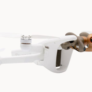
PARROT PROFESSIONAL
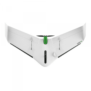
Parrot ANAFI Ai Drone
Key Features- Fly Farther with Dual-Band Wi-Fi/4G LTE
- Ideal for Photogrammetry, Filming & More
- Up to 4K/60 & 4K HDR10/30 Recording
- Twin Sensor Obstacle Avoidance System
- 0.46 cm/px GSD at 100′ Mapping Accuracy
- Up to 6x Lossless Zoom
- 14 EV Dynamic Range
- 6 Different Camera Modes
- 5 Autonomous Flight Modes
- Skycontroller 4 Remote Control Included
SKU: n/a -
-
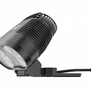
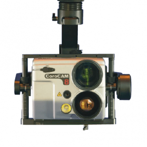
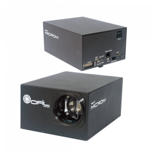
GIMBALS, CAMERAS, SENSORS
DayCor® micROM HD
DayCor® micROM HD is an innovative corona camera designed for use on UAV. It is electromagnetically shielded, small and light with ready interfaces to communication protocols. micROM HD is the first micro HD camera with dual sensors UV & Visible, capable of detecting and imaging corona in daylight.
SKU: n/a
SOFTWARE
DJI FlightHub 2
FlightHub 2 is an all-in-one cloud-based drone operations management platform that helps you achieve comprehensive, real-time situational awareness. Access all the information you need to plan drone missions, supervise your fleet, and manage the data you create, now from a secure cloud-based environment.
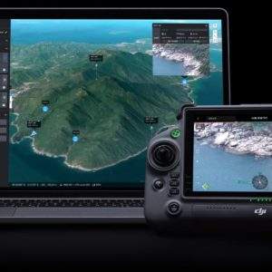
UgCS Enterprise
Live Video Feed Features
All the features and benefits of UgCS Pro.
Benefit from a live video stream from UgCS for DJI to UgCS
(currently compatible only with Win & Android)
UgCS Expert LIDAR Toolset
The UgCS LIDAR toolset unlocks the full potential of LIDARs enabling effective remote sensing without human error. Delivers everything that UgCS Pro delivers plus LIDAR capabilities.
Supports most popular LIDAR platforms: DJI, YellowScan, Riegl, PhoenixLIDAR, LIDAR USA, GeoCue, Rock Robotics, & GeoSun LIDAR
UgCS Mapper
Create Maps offline with UAV Drone Photogrammetry
Mapper is a lightweight software tool for making 2D maps and elevation out of drone imagery and video – purely offline.
Increase surveying productivity – validate the quality of dataset – collected images are suitable for map stitching, before leaving the survey area.
Higher flight safety – create up to date 3D map and elevation data, i.e., when default map sources are not accurate enough for safe mission planning.
UgCS ATLAS AI
ATLAS Optimses Drone & Satellite Geospatial Data Analysis
ATLAS leverages AI to automate time-consuming manual analysis of UAV & Satellite data, such as object counting, volume measurements, making a true DTM, and much more.
ATLAS contains its own AI-engine, which learns from users activity and automates regular data analysis tasks.
ATLAS can be taught to identify changes of assets, components, and geospatial data over time, to support various monitoring, inspection, and integrity activities.

Drone Show Software
Full Turnkey Solution
Drone Show Software provides tools to manage astonishing outdoor shows by controlling up to thousands of drones as flying pixels.
This drone system by SPH Engineering is the very first commercially available software that manages its flights with lights, fireworks, smoke generators, and any other payloads.
Drone Show Software allows anyone with drones, ambition and a choreographer to create mind-blowing drone shows.
Take your events to the next level with revolutionary drone show control software which is already highly valued in many entertainment industries.
Virtual Surveyor
SMART DRONE SURVEYING SOFTWARE. SURVEY EFFICIENTLY WITH DRONE DATA
Powerful analysis and visualisation of your drone surveys. Virtual Surveyor is ideal for civil construction, infrastructure, mining and quarrying projects of any size. From road surveying to topography mapping, volume calculations and cut/fill mapping, Virtual Surveyor gives you the tools to quickly and accurately track and optimise your project as it takes shape.

Aerial Data Processing Trainings: How Hobby Drone Pilots Can Turn Into Professionals
Drone piloting has come a long way since it was just a hobby for tech-savvy enthusiasts. Thanks to the increased accessibility of drones, more people are learning how to fly

The use of professional drones in archaeological research
One of the most remarkable archaeological trends of the last decades is the growing popularity of UAV – use in archaeological research. Drones allow archaeologists to explore large areas quickly, obtain
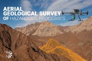
Aerial Geological Survey of Hazardous Processes
One of the world’s largest gas producers, the Middle East accounts for 38.4% of global gas production. In addition to the resource base and its timely reproduction through the development
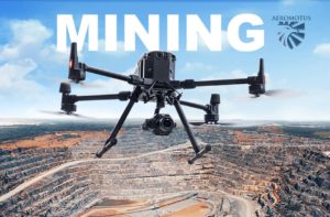
DJI Drones: An increasingly popular tool for mining companies
It’s official: drones are taking over the world. Or at least, they’re taking over all the cool jobs. We’ve already seen them delivering packages, inspecting bridges, and even herding sheep.

Aeromotus at the Big 5 Dubai – The International Building and Construction Show in Dec 2022
At Aeromotus, we believe, the Big 5 Show, unlike other events, has always been a distinct construction event providing leading-edge innovation, knowledge, and business opportunities for industry players around the
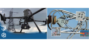
Webinar on use of UV Cameras on Inspections of Transmission Lines and Substations with DJI Matrice M300RTK Drone.
Aeromotus, a leading End-to- End Drone Technology company based in Dubai is hosting a webinar with their partner ZQ Photoelectric, a high-tech manufacturer involved in production of UV Cameras, IR