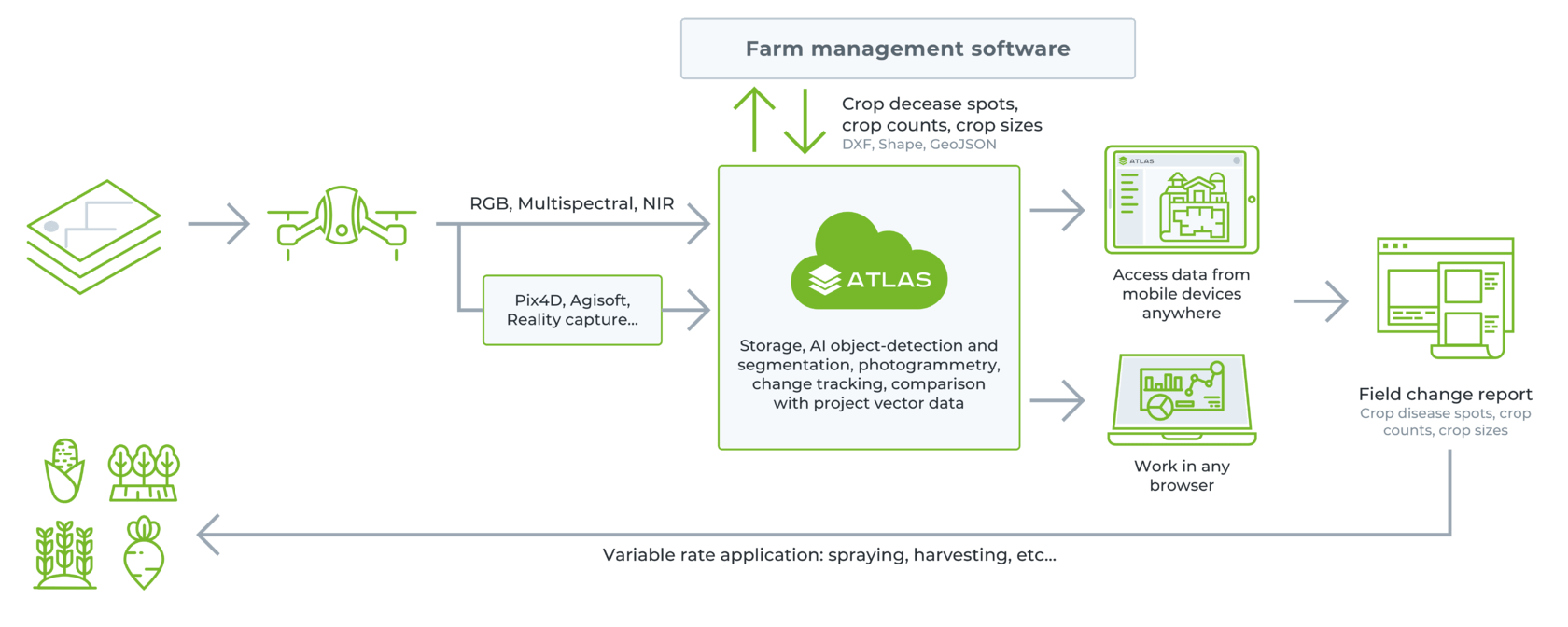
ATLAS Optimses Drone & Satellite Geospatial Data Analysis
ATLAS leverages AI to automate time-consuming manual analysis of UAV & Satellite data, such as object counting, volume measurements, making a true DTM, and much more.
ATLAS contains its own AI-engine, which learns from users activity and automates regular data analysis tasks.
ATLAS can be taught to identify changes of assets, components, and geospatial data over time, to support various monitoring, inspection, and integrity activities.
Optimize Drone & Satellite Geospatial Data Analysis
Detect and count objects and shapes, calculate volumes, track progress, vectorize projects, and many more
Product by SPH engineering
ATLAS leverages AI to automate time-consuming manual analysis of UAV & Satellite data, such as object counting, volume measurements, making a true DTM, and many more.
Main Features
Store & Collaborate
Keep all survey data in one place (raw files, point clouds, orthomosaics, DSM, DXF, KML, etc)
Assign survey tasks to pilots and get notified on task progress
Share data and reports in one click
Analyse & Report
Automate object detection, counting, and territory segmentation
Measure and annotate in 2D and 3D
Track progress of all changes on your worksite with visual reports
Visualize
Visualize elevation, orthomosaics & point clouds
Compare 2D/3D project designs with a current site model
Export generated reports
Detect objects
Annotate objects with uniform textures in one click with Magic Wand, and train AI to search for any regular and complex objects
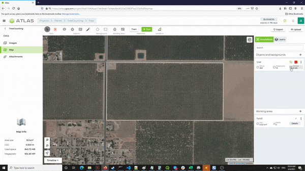
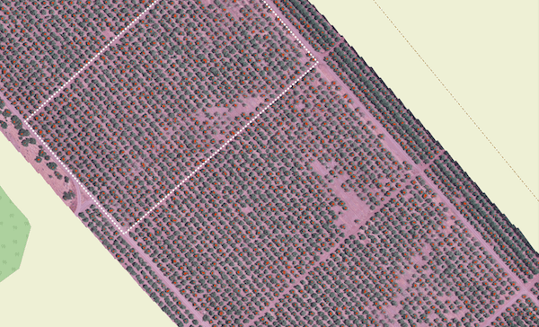
Count objects
Count objects of regular forms, such as 8715 trees on a plot 0.32 sq. km, with utmost precision and in no time.
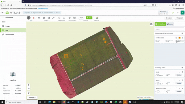
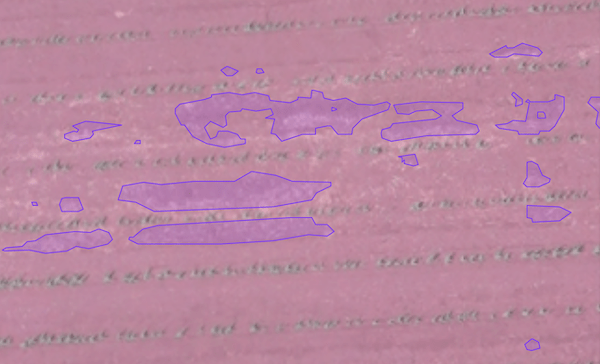
Measure areas
Automatic image segmentation helps calculate the size of complex objects and areas, such as fields covered by pests.
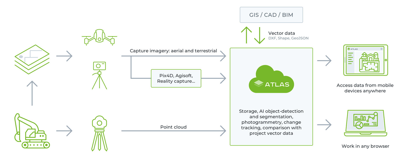
How ATLAS works
With 3 simple steps turn your aerial images into business insights!
1.Upload data
Upload images or orthomosaic to the ATLAS cloud or your locally deployed ATLAS On-Premises for higher data security
2.Visualise, annotate and analyze
Visualize geospatial data, annotate objects manually or with AI detectors, measure and analyze data
3.Export and share reports
Export results in GeoJSON, CSV, PDF and other formats or share them with one click with colleagues and stakeholders
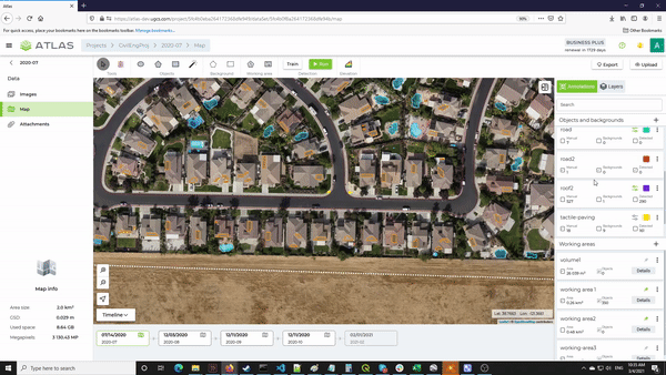
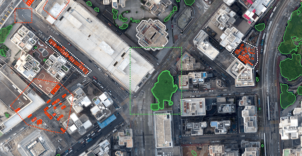
UAV Data Analysis for Construction & Urban Planning
ATLAS is an AI-driven platform that helps track and measure the progress of construction worksites and share up-to-date information with others, fostering collaboration & faster decisions making
Timely construction reporting
and no more manual routine in UAV data analysis and report generation! Share reports with your contractors and stakeholders without delays on the day of surveying.
Improve teamwork and coordination
within your team of co-workers and subcontractors. Share data in one click as direct links accessible from mobile (iOS/Android) and desktop. Increase situational awareness of all project stakeholders using very simple and visual reporting.
Sensitive data is secured
ATLAS can be installed on premises for storing, processing and exchanging the most sensitive data.
Main Features
ATLAS contains its own AI-engine, which learns from users activity and automates regular tasks in construction and maintenance.
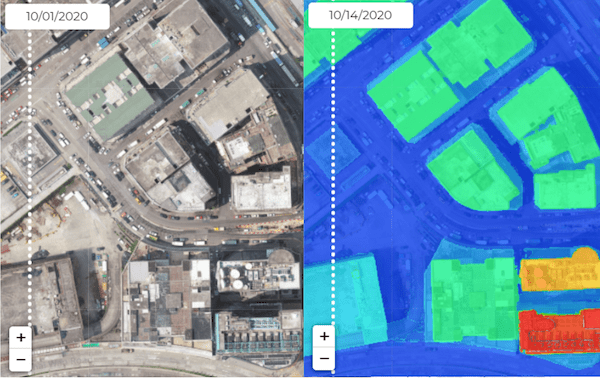
Track progress and compare
Keep the data of all construction assets on the timeline with easy access to different slices of the same object along with ability to compare, and receive visual reports for all changes in a specified working area. Store raw aerial photography, orthomosaics, DSM, vector data (DXF, KML, Shape), and any additional files.
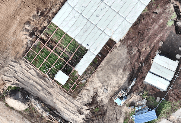
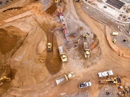
Count objects, measure areas, calculate volumes
Make a territory segmentation, highlight stockpiles and calculate volumes automatically with ATLAS AI. It also allows detecting heavy vehicles and vegetation on top of a pile and remove them from DSM to make volumes more realistic.
Verification of subcontracted work
ATLAS helps you validate work of subcontractors before acceptance. Automatically detect trenches and roads on orthomosaics, calculate boundaries and area sizes.
Waste management
Track location of different wastes generated during construction process. Tires, old pallets, broken vehicles and other – all this things can be counted and segmented.
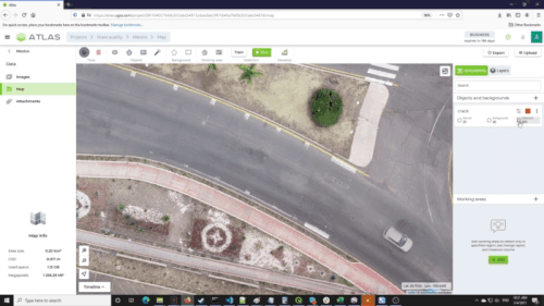
Inspect asphalt or concrete for damages
Detect cracks and scratches on concrete and asphalt surfaces on both raw imagery and orthomosaics. Resulting report can be used by repair & maintenance teams to localize defect position and estimate required materials and human resources.
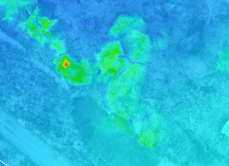
Elevation mapping
ATLAS provides tools to clean DSM from artificial objects to make accurate elevation profiles and slope measurements.
The workflow
UAV Data Analysis for Precision Agriculture
ATLAS is an AI-driven digital platform for precision farming insights based on drone, aerial, satellite data and use of AI detectors.
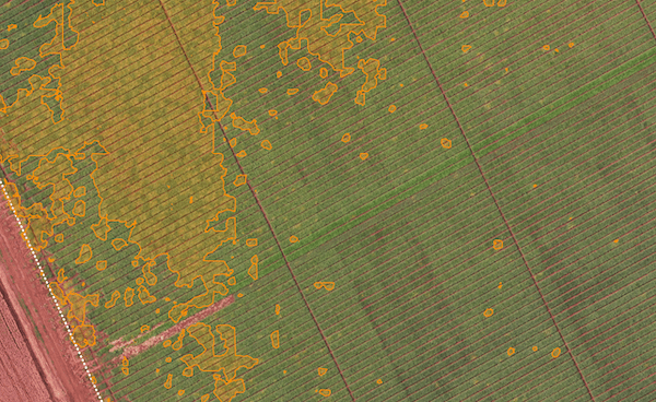
Fast crop scouting
Make an automatic territory segmentation of crop imagery and calculate actual crop areas for insurance, crop scouting and yield prediction more accurately.
Faster data markup
and no more manual routine in UAV data analysis and report generation! Share reports with all the stakeholders without delays on the day of surveying and make fast decisions.
Minimize yield losses
Increase farm productivity and preserve crop quality through UAV data analysis. Run AI detector to promptly identify pests, diseases and weeds on the fields and plan the response.
Main Features
ATLAS contains its own AI-engine, which learns from users activity and automates regular tasks in agriculture, thus leading to better decisions
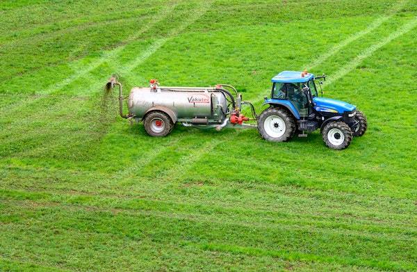
Use machinery & chemicals efficiently
Excessive use of pesticides results in less efficient and less productive crops. To approach farming in sustainable ways, accurately measure the area covered by weeds for calculating the minimum required volume of chemicals spraying, as well as amount of heavy machine work hours and fuel for the focused deployment of weed killers and pesticides.
Provide data for crop insurance claims
UAV data effectively supports insurance claims for guaranteed payouts. Make an automatic territory segmentation and calculate areas of crop damage and total loss. Compare the same field before and after the damage using visual reports on the timeline.
Track progress and compare
Keep the data of all construction assets on the timeline with easy access to different slices of the same object along with ability to compare, and receive visual reports for all changes in a specified working area. Store raw aerial photography, orthomosaics, DSM, vector data (DXF, KML, Shape), and any additional files.
Weed and pest detection
Localize weed patches, detect pests and areas devastated by locust or other insect to assess in-season crop health. An accurate geographical positions of pests and weeds can be generated for manual inspection or any VRA.
Crop yield prediction
Receive valuable insights for agriculture intelligence from UAV data with the help of territory segmentation, areas measurements and image analysis
Count planted trees
ATLAS provides tools to clean DSM from artificial objects to make accurate elevation profiles and slope measurements.
The workflow
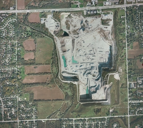
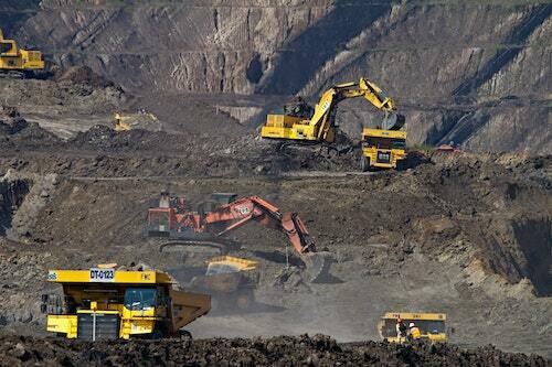
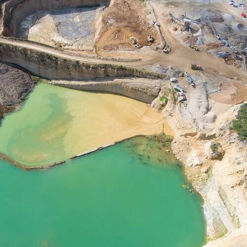
UAV Data Analysis for Open-pit Mines & Quarries
Take timely data-driven decisions at every stage of the mining lifecycle with ATLAS AI-powered platform
Analyze drone data faster
ATLAS removes the manual routine and saves hours of manpower in drone data analysis. Share the critical data with all the stakeholders in one click as direct links accessible from mobile (iOS/Android) and desktop.
Improve the safety of your team
Drone survey in replace of a traditional ground survey coupled with AI-based drone image processing allows keeping people off the ground, away from areas of stockpiles, blasting operations and other hazards.
Cost-effective quarry monitoring
Perform regular monitoring of your quarry or pit (calculate stockpile sizes, visualize site conditions, check machinery, etc) with higher accuracy compared to manual labeling and analysis and at a fraction of a cost.
Main Features
ATLAS contains its own AI-engine, which learns from user’s activity and automates regular inspections of pits and quarries
Quarry monitoring
Make the regular monitoring of the quarry more efficient by automating routine tasks. Highlight stockpiles, measure areas and calculate volumes automatically, build elevation maps. Calculate materials to be removed before further extractions. Search for potential issues using a territory segmentation.
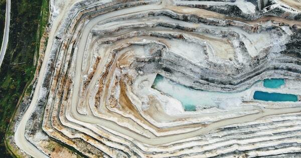
Auditing the stockpile
ATLAS utilizes computer vision and AI to inexpensively calculate stockpile inventories on a regular basis. Measure stockpiles and excavated materials in open pits, compare volume and track changes with a higher precision and time efficiency. Detects heavy vehicles and vegetation on top of a pile and remove them from DSM to make volumes more realistic.
Support drilling and blasting operations
Analysis of pre-blast survey data (pre-blast block condition and volumes) helps calculate drill depth and plan the blast. Automatically measure stockpile volumes to accelerate clearance of the blast area. Preserve the visual reports of the site before and post-blast for comparisons in case of an accident and measurements of blast efficiency.
Plan the traffic in the quarry
ATLAS enables automatic assessment of haul roads on a regular basis for accurate traffic planning and optimization. Measure slopes, calculate haul road length, search for visual patterns with ATLAS AI detectors to assess the road conditions. Localize and count heavy machinery with object detection and counting functions.
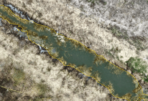
Optimize water management
Whether you mine aggregates or mineral resources, use AI detectors and their capabilities (count objects, measure areas, calculate volumes, and create elevation profiles) to optimize water management plan for your quarry of pit. Regularly measure tailing storage and search for potential issues before disastrous changes.
Track progress and compare
Keep the data of all construction assets on the timeline with easy access to different slices of the same object along with ability to compare, and receive visual reports for all changes in a specified working area. Store raw aerial photography, orthomosaics, DSM, vector data (DXF, KML, Shape), and any additional files.
The workflow
ATLAS is simple to use not requiring GIS or data science knowledge
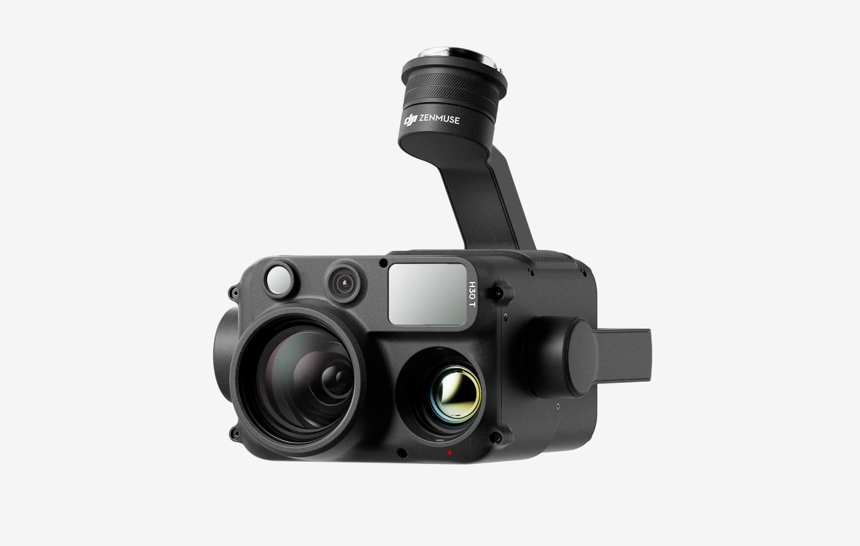
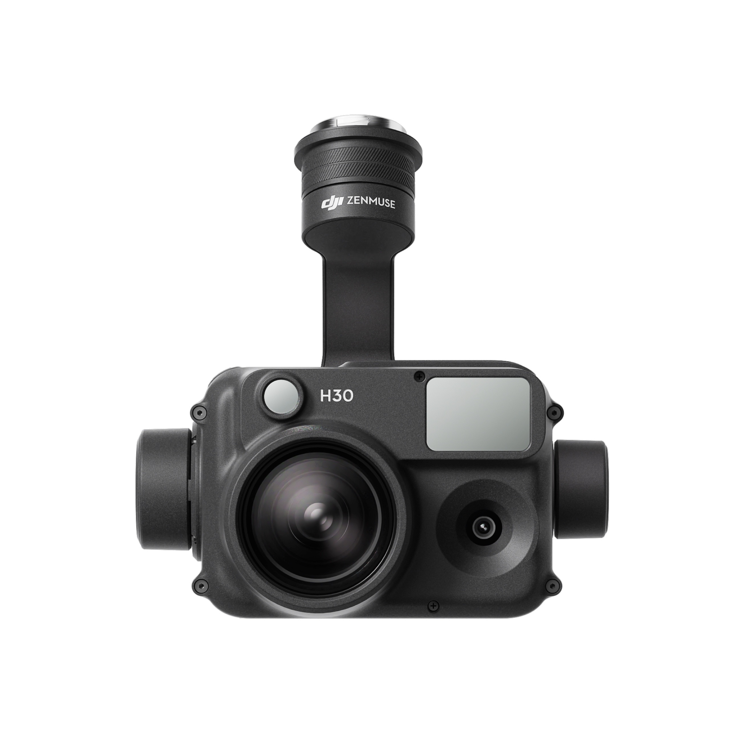
The all-weather, multi-sensor flagship Zenmuse H30 Series integrates five major modules—a wide-angle camera, a zoom camera, an infrared thermal camera, a laser range finder, and an NIR auxiliary light. Employing cutting-edge intelligent algorithms, it revolutionizes perception and imaging standards, transcending the limitations of day and night vision. This makes it effortlessly suitable for a variety of operations, including public safety, energy inspection, water conservation, and forestry.
The all-weather, multi-sensor flagship Zenmuse H30 Series integrates five major modules—a wide-angle camera, a zoom camera, an infrared thermal camera, a laser range finder, and an NIR auxiliary light. Employing cutting-edge intelligent algorithms, it revolutionizes perception and imaging standards, transcending the limitations of day and night vision. This makes it effortlessly suitable for a variety of operations, including public safety, energy inspection, water conservation, and forestry.
This website uses cookies so that we can provide you with the best user experience possible. Cookie information is stored in your browser and performs functions such as recognising you when you return to our website and helping our team to understand which sections of the website you find most interesting and useful.
Strictly Necessary Cookies
Strictly Necessary Cookie should be enabled at all times so that we can save your preferences for cookie settings.
If you disable this cookie, we will not be able to save your preferences. This means that every time you visit this website you will need to enable or disable cookies again.
3rd Party Cookies
This website uses Google Analytics to collect anonymous information such as the number of visitors to the site, and the most popular pages.
Keeping this cookie enabled helps us to improve our website.
Please enable Strictly Necessary Cookies first so that we can save your preferences!
Additional Cookies
This website uses the following additional cookies:
(List the cookies that you are using on the website here.)
Please enable Strictly Necessary Cookies first so that we can save your preferences!