GENERAL
Dimensions: 152×110×169 mm
Weight Approx: 900 g
Power: 30 W
IP Rating: IP44
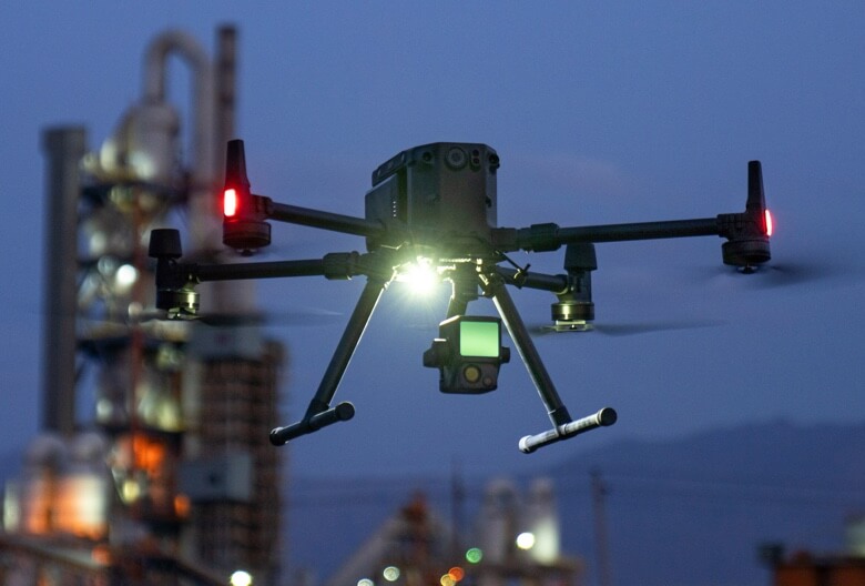
Supported Aircraft: Matrice 300 RTK
Operating Temperature Range: -20° to 50° C (-4° to 122° F)
Storage Temperature Range: -20° to 60° C (-4° to 140° F)
SYSTEM PERFORMANCE
Detection Range: 450 m @ 80% reflectivity, 0 klx
;190 m @ 10% reflectivity, 100 klx
Point Rate Single return: 240,000 pts/s
;Multiple return: 480,000 pts/s
System Accuracy Horizontal: 10 cm @ 50 m
;Vertical: 5 cm @ 50 m
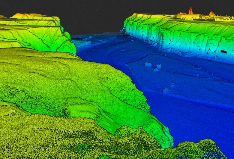
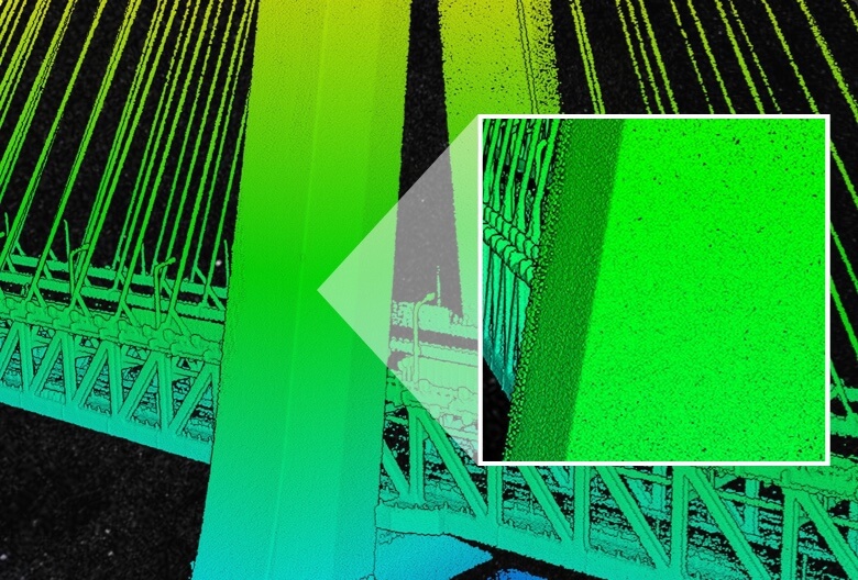
Real-time Point Cloud Coloring Modes: True color; coloring by reflectivity; coloring by elevation
LIDAR
Ranging Accuracy: 3 cm @ 100 m
Maximum Returns Supported: 3
Scan Modes: Repetitive line scan mode, non-repetitive petal scan mode
FOV: Repetitive line scan: 70.4°×4.5°
; Non-repetitive petal scan: 70.4°×77.2°
Laser Safety: Class 1
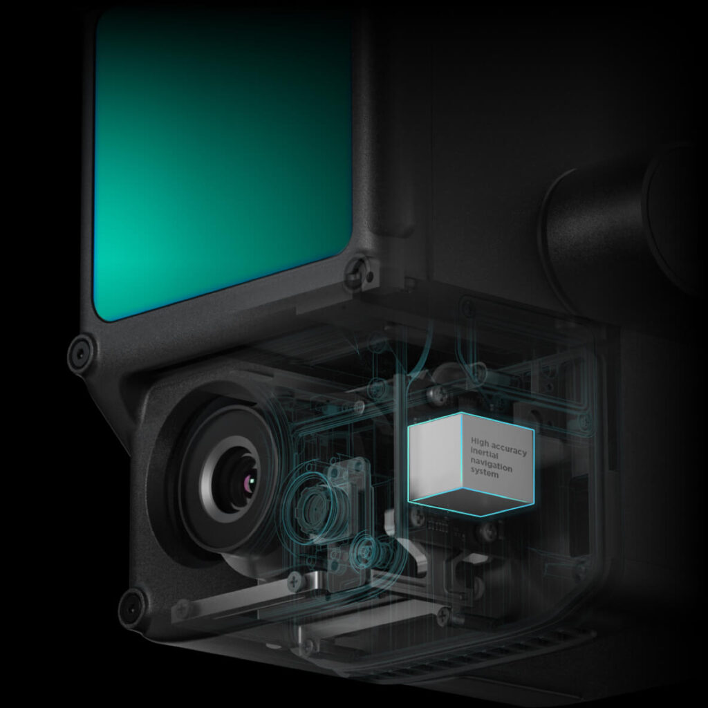
INERTIAL NAVIGATION SYSTEM
IMU Update Frequency: 200 Hz
Accelerometer Range: ±8 g
Angular Velocity Meter Range: ±2000 dps
Yaw Accuracy: Real-time: 0.18°, Post-processing: 0.08°
Pitch / Roll Accuracy: Real-time: 0.03°, Post-processing: 0.025°
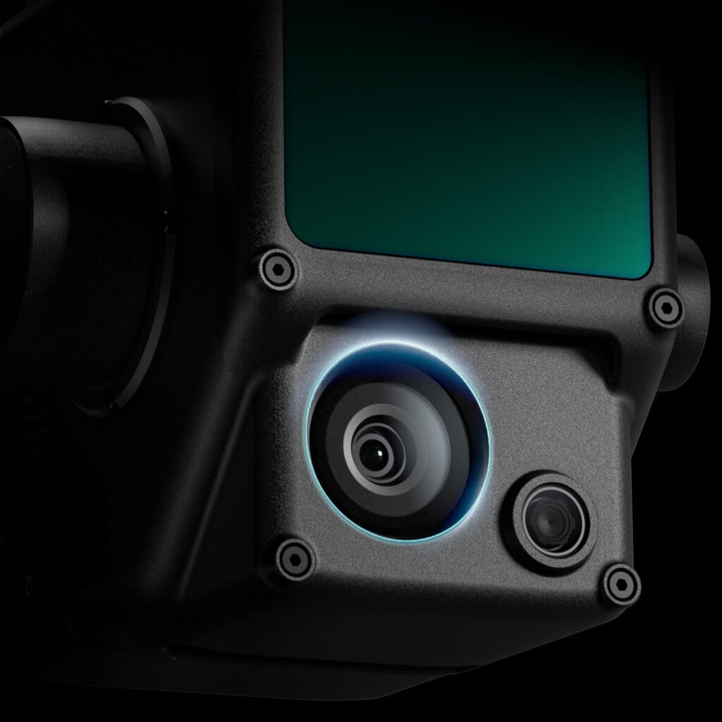
AUXILIARY POSITIONING VISION SENSOR
Resolution: 1280×960
FOV: 95°
RGB MAPPING CAMERA
Sensor Size: 1 inch
Effective Pixels: 20 MP
Photo Size: 4864×3648 (4:3); 5472×3648 (3:2)
Focal Length: 8.8 mm / 24 mm (Equivalent)
Shutter Speed: Mechanical Shutter Speed: 1/2000 – 8 s / Electronic Shutter Speed: 1/8000 – 8 s
ISO: Video: 100 – 3200 (Auto), 100 – 6400 (Manual)
Photo: 100 – 3200 (Auto), 100 – 12800 (Manual)”
Aperture Range: f/2.8 – f/11
GIMBAL
Stabilized System: 3-axis (tilt, roll, pan)
Angular Vibration Range: 0.01°
Mount: Detachable DJI SKYPORT
Mechanical Range: Tilt: -120° to +30°; Pan: ±320°
Operation Modes: Follow/Free/Re-center
DATA STORAGE
Raw Data Storage: Photo/IMU/Point cloud data storage
Point Cloud Data Storage: Real-time modeling data storage
Supported microSD Cards: microSD: Class 10 or UHS-1 rating or above; Max capacity: 256 GB
POST-PROCESSING SOFTWARE
Supported Software: DJI Terra
Data Format: DJI Terra supports exporting standard format point cloud models:
Point cloud format: PNTS/LAS/PLY/PCD/S3MB format
Reconstruction model format: B3DM/OSGB/PLY/OBJ/S3MB format
What is the protection level of the Zenmuse L1?
The L1 has an IP54 rating according to the IEC60529 standard. This means that it is protected against solid objects over 1mm in size and against water splashed from all directions. The protection level is not permanent however and will decrease over time due to device wear.
To ensure the highest levels of protection:
- Before installing, make sure that the interface and surface of the gimbal are dry;
- Before use, make sure that the gimbal is firmly installed on the drone and the SD card protective cap is clean, free of foreign objects, and closed;
- Before opening the SD card protective cap, wipe the surface of the drone clean.
What aircraft is the L1 compatible with?
The L1 is compatible with the M300 RTK. Before using, please upgrade the firmware of the drone and remote controller to the latest version.
Which apps are compatible with the L1?
The L1 currently supports only the Android version of the DJI Pilot App.
Does the camera require an SD card?
The camera requires a MicroSD card with Class 10 or higher transmission speed or rated UHS-1 , with up to 256 GB supported.
What is the Field of View (FOV) of the L1’s Lidar?
In Non-repetitive Scanning mode, the FOV is 70.4°x77.2°.
In Repetitive Scanning mode, the FOV is 70.4°x4.5°.
What is the maximum measuring range of the L1?
The maximum measuring range of the L1 is 190m@10%, 100klx ; 450m@80%, 0klx.
The recommended typical working height is 50m-120m.
What is the scanning frequency of the L1?
The L1 provides three scanning frequencies: one/two returns: 80K/s, 160K/s, and 240K/s; three returns: 80K/s, 240K/s.
How many scanning modes does the L1 have?
The L1 has two scanning modes: Non-repetitive Scanning mode and Repetitive Scanning mode.
How many returns does the L1 support?
The L1 supports 3 types of returns:
- One return;
- Two returns;
- Three returns.
What does the L1’s Point Cloud LiveView do?
The L1 collects point cloud models based on RTK and displays the collected models on Pilot in real time.
The following features are supported:
- Rotating, dragging, zooming, quick switching of perspectives, and centering;
- Multiple coloring modes including RGB, reflectivity, elevation and distance;
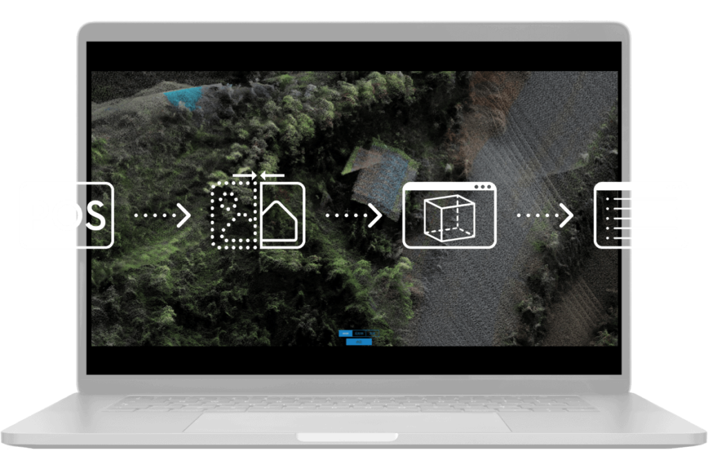
How does the L1 perform high-accuracy post-processed modeling?
For high-accuracy post-processed modeling, you can import the data from the SD card into DJI Terra with one click. This will generate a colorized point cloud model with high-accuracy PPK-IMU position and orientation calculation supported.
Which model reconstruction formats does the L1 support?
The L1 supports the following model reconstruction formats:Point cloud formats: PNTS, LAS, PLY, PCD and S3MB
Which types of flight missions does the the L1 support?
The L1 currently supports Mapping, Linear Flight Mission, Oblique and Waypoint.
What is the IMU accuracy of the L1?
In typical operating scenarios, the IMU accuracy of the L1 is 0.025°(roll/pitch)/0.15°(yaw). The accuracy was measured under the following conditions in a DJI laboratory environment: after a 5-minute warm up, using Mapping Mission with Calibration Flight enabled in DJI Pilot, and with the RTK in FIX status. The relative altitude was set to 50 m, flight speed to 10 m/s, gimbal pitch to -90°, and each straight segment of the flight route was less than 1000 m. DJI Terra was used for post-processing.
What is the L1’s auxiliary vision sensor used for?
The vision sensor provides altitude data. This means that if the GNSS signal temporarily fails, the aircraft’s accuracy will not be affected for up to 60 seconds. Support coming soon.
What is the L1’s RGB camera used for?
The RGB camera of the L1 provides basic functions for taking photos and recording videos and provides real-time color information for the point cloud data during the scanning process. This allows the L1 to output true color point clouds and reality models.
Note that Lidar scanning and video recording cannot work simultaneously.
What is the surveying and mapping accuracy of the L1?
The vertical accuracy of the L1 can reach 5 cm and the horizontal accuracy can reach 10 cm. The accuracy was measured under the following conditions in a DJI laboratory environment: after a 5-minute warm up, using Mapping Mission with Calibration Flight enabled in DJI Pilot, and with the RTK in FIX status. The relative altitude was set to 50 m, flight speed to 10 m/s, gimbal pitch to -90°, and each straight segment of the flight route was less than 1000 m. DJI Terra was used for post-processing.
Can the L1 work at night?
The Lidar module of the L1 has active detection capability which can scan terrain to collect point clouds during nighttime or other low light conditions.
Which scanning mode does the L1’s Lidar module adopt?
The Lidar module of the L1 adopts an Advanced Frame Scanning mode. This ensures that all point clouds collected are valid point cloud data.
How efficient is the surveying and mapping operation of the L1?
At a flight height of 100 m and a velocity of 13 m/s, a single flight with the M300 RTK and the L1 can collect data covering an area of 2 km2.
What are the application scenarios of the Zenmuse L1?
The L1 can be widely used in multiple scenarios including:
- Topographic surveying and mapping
- Power transmission line corridor modeling
- Emergency response surveying and mapping
- Detailed modeling
- Agriculture & forestry investigation
On which gimbal of the the M300 RTK can the L1 be mounted?
The L1 can be mounted on the right downward gimbal port (when facing the drone) of the M300 RTK. Currently, only suppot single gimbal mode.

")