Drone/UAV Applications at Present and in the Future Leave a comment
Drone/UAV Applications at Present and in the Future
Marine
Gradually Unmanned Aerial Vehicles become prevalent in the maritime industry. First, there were made lots of trials but today, drones, used in the maritime industry can do the following:
- deliver packages to vessels;
- track the traffic congestions on roads that lead to and from the port;
- give a bird’s eye view of the port and the work of its infrastructure;
- perform hull inspections;
- help scientists analyze the condition of the protective coatings of tanks and vessels;
- identify the defects of vessels;
- keep tabs on vessels that anchor in the sea;
- control the condition of container stacks;
- check, whether vessels are in safety.
These are the main purposes of using drones in the maritime industry. The project, which offers to equip drones with emission sensors that can control whether there are any emissions from vessels, is on the stage of development now.
In sober fact, drones used in maritime industry can improve the safety of ports and vessels, and speed up the process of data gathering. Camera-equipped drones are deemed to be much better, more effective and cheaper solution as compared to helicopter usage. Drones are an ideal and cost-effective method which can easily find effective and cost-effective ways for checking vessels for substantial corrosion or fractures and damages.
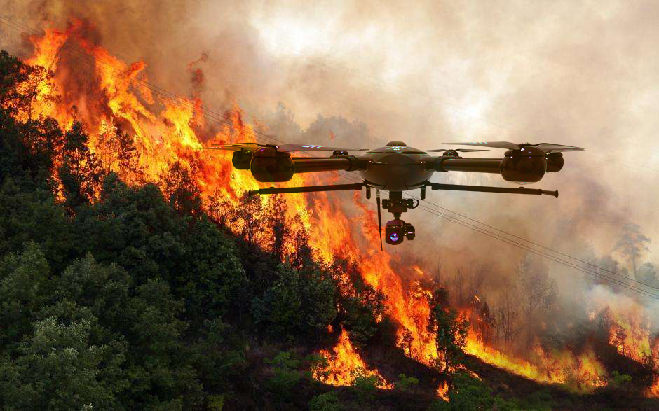
Firefighting
UAVs also find their use in firefighting as well. Their primary purpose in this industry is to aid crews to locate the main seat of the fire. Furthermore, industrial drones allow them to check how the fire is progressing.
The drone technology in firefighting industry guarantees the safety of firemen because drones offer much better visibility and don’t make firefighters risk their lives with the aim to identify the fire seat. Deploying a drone allows the staff to check the fire more thoroughly and look at it from an absolutely new perspective.
To analyze the fire, pilots equip drones with Infrared Thermal Imagers. Their primary purpose is to find out the infrared radiation characteristics of the signal of an object. After that, the signal can be converted into visible images. This information is crucially important for fire monitoring.
UAVs are also widely used for the investigation of fire loss. They allow firefighters to see a full scene of damage caused by the fire. Thanks to UAVs, it is possible to check what places suffered from fire most of all.
The most important factor is that drones allow firefighters to locate the victims of the fire. They provide the crew with the necessary data which allows them to plan the best rescue measures faster. Thanks to the bird’s eye view offered by drones, firefighters can search for missing individuals. The advanced sensors, cameras, and the capability, allowing users to transfer the shot footage wirelessly, really speed up the rescue operations.
Drones can check structural integrity. As a rule, during each fire, no one can guarantee that the building won’t collapse. The drones, equipped with imaging systems can help firefighters detect the structural integrity of a building.
Some drones can be equipped with payloads that can carry medicines, blood or some other equipment used in emergency situations.
Taking into account the number of situations when UAVs can be irreplaceable tools of firefighters, you see that very soon, each rescue operation won’t do without drones.
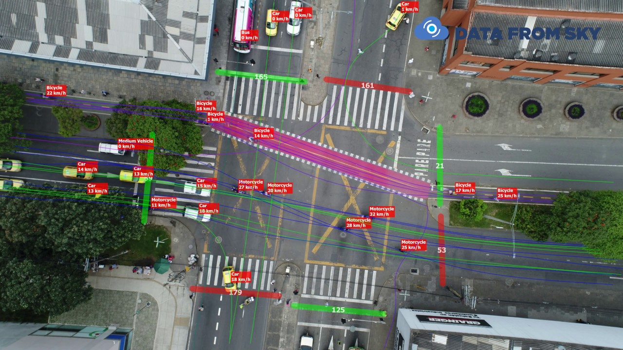
Traffic Monitoring
The steady increase of vehicles on roads obliges transportation managers to search for the new solutions that can reduce the traffic congestion on roads. In sober fact, monitoring from the sky allows scientists to optimize the road traffic systems. For that reason, the use of UAVs is the advanced solution that can help solve the existing traffic systems. The drone usage is an excellent data collection method.
Traffic jams are a significant problem of any metropolis which results in a drain on the economy. For that reason, to help the society solve this issue, experts started using UAVs. Drone surveillance of traffic jams has lots of benefits. They are as follows:
- No Satellites are Required. The usage of satellite systems to monitor traffic is really expensive. UAVs are cheaper and offer the same results. Furthermore, drones can be positioned at various locations.
- Enhanced Decision Making. The data gathered by drones can be used with the aim to find out what positions are under a load of traffic. This information helps experts reduce jams.
- Excellent Data Acquisition Possibilities. The information gathered through the use of drones helps local authorities spot trends in the traffic flow.
Drones equipped with HD Zoom Cameras can not only monitor the state of the traffic jam and spot trends, they can also help find out the license of the target car from the sky. In some instances, it is necessary to find out this information for reasons of public safety.
Media
The business of media is also rapidly changing. Modern technological advances really changed the work of journalists. These days, one of the main tools of all journalists is drones. Through the use of these flying machines, journalists can get a bird’s eye view of lots of events and places. Besides, journalists frequently defer to the services of drones in case it is impossible to reach a reporter on the ground.
The prime objective of any drone is to provide users with the footage from hard-to-reach points. The use of drones is cheaper as compared to hiring a helicopter. In current times, journalists frequently use drones with the aim to gather information in a foreign war zone, to monitor disasters or check the fields.
Besides, there is a term – “drone journalism” or the use of drones for the purposes of journalism. The main thing journalists pay attention to is the camera characteristic features of a drone. The result of their work fully depends on the image quality.
Police
This industry more frequently defers to the drone use. It is deemed to be that drones are the newest toys for cops to perform their everyday job. The prime objective of all UAVs is to provide policemen with a bird’s eye view of disaster scenes. Drones can easily get to those places where human beings can’t physically go. Except for an ordinary bird-eye view, drones allow police to make a three-dimensional area of a place.
Besides, a combination of drones with facial recognition software, high-powered audio recording device or infrared cameras can provide the police departments with lots of useful information about ongoing crime scenes.
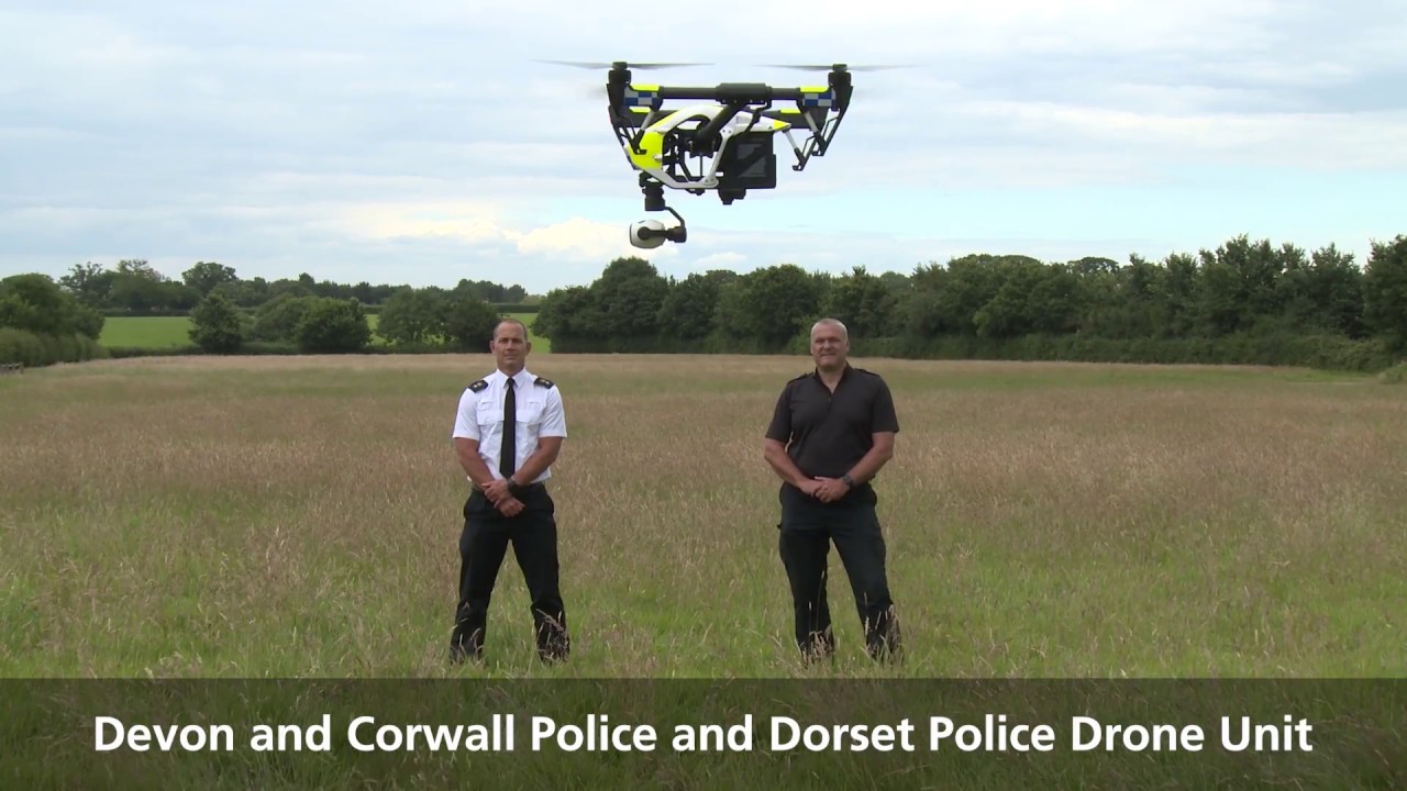
As a rule, police choose the following equipment:
- Long Endurance drones (UAVs that can fly more than 20 minutes);
- Wireless Base Stations;
- Various Payloads that serve for fast shipment of necessary equipment to hard-to-reach places.
- Ground Control Stations that guarantee the stable drone flights.
The drones provide police with the necessary information that allows them to get to the truth faster. Police drone surveillance has lots of advantages. They are as follows:
- Active Shooter. When policemen are engaged in active shooter situations, they face lots of obstacles that don’t allow them to get the truthful information about the location of shooters. Drones allow them to get a detailed aerial view of the surrounding landscape.
- Through the use of drones, this operation will be much easier.
- Search and Rescue missions.
- Crowd Monitoring during such venues as parades, shows, concerts or sporting events.
In this case, drones can be equipped with HD Zoom Cameras, Infrared Thermal Imagers, 4in1 device, etc.
Drone for Mapping
The prime objective of mapping is accuracy. Drones can guarantee this. Autonomous drones have become the main tools for topographic surveys. Because of the fact that the price for drones fell for the previous several years, lots of industries like agriculture, resource management or construction started using drones for gathering information about the site.
Using a drone for surveying allows users to create accurate digital elevation models 10 times faster than the use of traditional methods. A drone allows users to make lots of aerial photos from various angles. After that, it is possible to find similar points on different photos with the help of special software.
Furthermore, drones and software capable of acting on the point clouds are easier to use and cheaper as compared to traditional methods. As a rule, digital terrain models created by drones look the same as the ones generated by traditional methods. Nevertheless, this method is cost-effective and richer in details.
The drones can calculate the flight path, can capture all required images and return to home when the mission is completed.
To conduct a mission, UAVs are equipped with special cameras, able to transmit different types of GIS data.
Besides, this method is environmentally friendly. Mapping drones are developed only with the aim to record and interpret data. For instance, an oblique camera is designed for 3D mapping and oblique photography.
Drones can be used in aerial geological mapping data detection, transmitting a fully 360-degree three-dimensional coordinates and distance in real-time, accompanied with the calibration of reflectance measurement. Drones can provide accurate, rapid and comprehensive geological data according to the required geological measurements in agriculture, electric power, geological mapping, etc.
Forest Protection
Drone technology also offers a plethora of environmental protection apps, offering fast, simple and not expensive solutions. There are lots of projects where UAVs can be applied: erosion monitoring, glacial feature modeling, species identification, animal counting, river or food assessment, etc.
Depending on the purpose, different types of cameras are used. The camera or any other payload, carried by a drone has a direct impact on the image quality. The most frequently used aerial imaging sensors are the following ones:
- RGB cameras. Such cameras receive data in the visible spectrum. As a rule, all photos made through the use of these cameras can be transformed into 2D orthomosaics or 3D surface models. The primary purpose of such sensors is to develop terrain models, keep tabs on coastal erosion, etc.
- Red-edge (RED), Near-infrared (NIR) and Multispectral cameras. All these cameras receive data across bands in the visible and non-visible spectrums. This information helps scientists compute vegetation indices.
- Thermal cameras. They are used with the aim to count treetop orangutan nests and seals. Besides, they allow users to assess the spread of wildfire.
Border Patrol. Drones for security
Drones also help protect borders. Besides, these days, lots of border patrol agents have drones at their disposal. To make the surveillance more effective, UAVs can be equipped with live-feed video cameras, facial recognition technology, thermal imaging or backend software tools.
Border patrol is the area, where drones are really necessary because they simplify the procedure of monitoring borders. Nevertheless, in this case, certain rules and regulations should be followed.
Power Line Patrol
Advanced drone technology is also used with the aim to patrol high-voltage lines or power line inspections. Using UAVs is cheaper as compared to traditional methods. Besides, drones allow specialists to take photos from various angles (it is impossible to do the same with helicopters).
A safety piece is one more benefit because it is not necessary to have anyone in a manned aircraft during an inspection.
As a rule, specialists perform their operations with the help of the following equipment, used for power line patrol and inspection:
- Long endurance drones.
- HD Zoom Camera.
- Ground Control Stations.
- Thermal images.
- Data post-processing software.
This equipment helps specialists to perform their operations during extreme weather conditions or work in extreme environment (such as rivers, lakes, high mountains, etc.). Besides, it is possible to perform operations round-the-clock.
Thermal Imagers help users identify various obstacles that aren’t viewable by naked eyes. UAVs also allow users to get data, which is convenient for storage.
Emergency Response
Using drones for emergency management isn’t anything new. The drone technology offers emergency management an absolutely new way of handling various operations. In other words, it gives a new perspective for solving various issues more effectively. When it comes to emergency management, drones have lots of applications. Their overarching goal is to provide emergency management with aerial footage, allowing them to look at the crisis from the different perspective.
Besides, the drone technology allows the emergency personnel not to enter potentially dangerous zones. UAVs are widely used by:
- Fire departments;
- Police departments;
- Search and rescue departments.
Drones equipped with various payloads can deliver medicines or medical equipment to hard-to-reach places. UAVs equipped with infrared imaging can also be very useful in different incidents.
In current times, various rescue operations use drones with the aim to deliver a special medical kit, comprising emergency supplies.
Recently, a drone, which can carry automated external defibrillators, was developed. This tool drastically reduces emergency response times thus giving more chances to a victim to survive.
Military Uses of Drones
Except for a number of other purposes, UAVs also found lots of applications in the defense world. In current times, the army of almost each country is endowed with drones
So, UAVs are used in the following way:
- Bomb detection. As a rule, drones are small. For that reason, they can easily penetrate into different spaces. Effective cameras, added to drones allow them to be the main tools for the bomb detection.
- Protect lives of soldiers. With the help of drones, they are armed with live video remote communications.
- Drones allow soldiers to monitor the enemy or protect forces.
- UAVs are the main tools that simplify the search operations. For instances, when the search operation is performed at night, it is possible to equip a drone with Thermal Images and Visible Light with VOx Chip. It can help soldiers search for the victims that may disguise under the forest, snow or grass.
- Drones can be equipped with dual optical target trackers. As a rule, this device carries the HD visible TV camera and the IR camera. They can be operated manually and automatically track the target.
Except for the above mentioned purposes, UAVs can also be used for surveillance, close air support, precision strike, route clearance, terminal air guidance, etc.
Aeromotus provides a software for any purposes by PIX4D company.