AgEagle Unveils the MicaSense RedEdge-P Drone Sensor
Doubling the Resolution and Capture Rate of the Market-Leading RedEdge-MX™, and Unleashing Extensive, Highly Precise Data Analysis Capabilities for Agriculture, Forestry and Land Management Drone Programs.
WICHITA, Kan & SEATTLE – October 26, 2021 – (GLOBE NEWSWIRE) – AgEagle Aerial Systems Inc. (NYSE American: UAVS) (“AgEagle” or the “Company”), an industry-leading provider of full-stack drones, sensors and software, today announced the launch of MicaSense’s latest innovation in leading-edge drone sensor technology – the RedEdge-P.
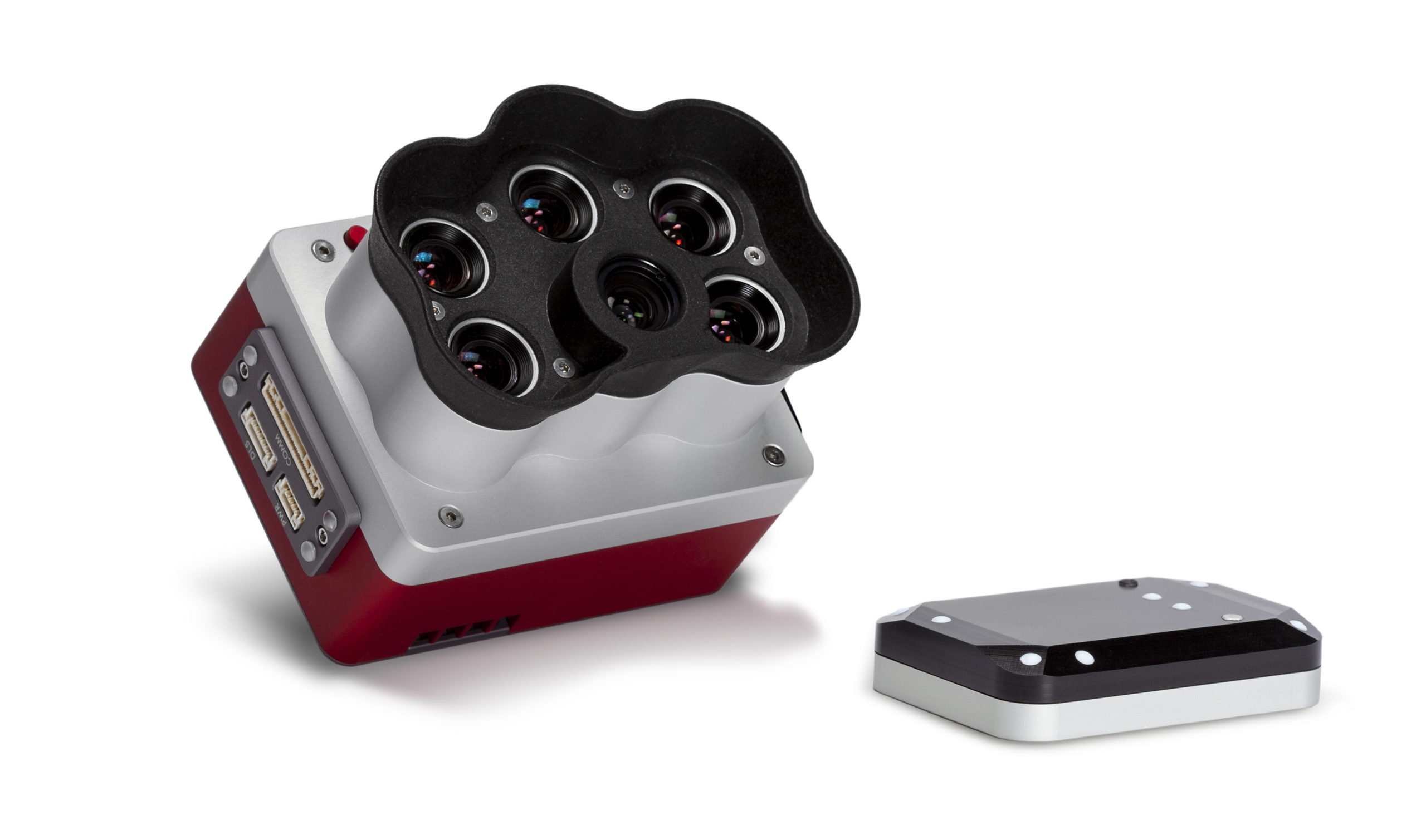
Offering three times the capture speed and twice the spatial resolution of the RedEdge-MX™, the all new RedEdge-P builds on the legacy of the rugged, high-quality, multispectral sensor that the industry has come to trust and adds the power of a higher resolution, panchromatic band to double the output data resolution. A single camera solution which is compatible with a wide array of drone aircraft ranging from large fixed wing to small multirotor, RedEdge-P captures calibrated high-resolution multispectral and RGB imagery with an optimized field of view and capture rate for efficient flights. This solution seamlessly integrates a high resolution, all-color imager with synchronized multispectral imagers to enable pixel-aligned outputs at previously unattainable resolutions, while maintaining the efficiency and reliability of its RedEdge™ legacy. Processing of data outputs will be enabled through industry standard software platforms, including AgEagle’s Measure Ground Control.
Agricultural professionals who favor simplification and uniformity of equipment and are looking for a reliable and efficient way to capture radiometrically calibrated RGB and multispectral data, need look no further. With RedEdge-P, they will benefit from a sensor that can enable effective plant counting and spectral analysis of small plants. Likewise, federal, state and local government and commercial forestry enterprises will also benefit from precise, efficient data collection and tree-level analysis as opposed to being limited to analyzing large swaths of land to make critical forestry management decisions.
Justin McAllister, Vice President of Research and Development at MicaSense, an AgEagle company, stated, “We are very proud to be introducing what we believe is the commercial drone industry’s best solution for capturing high-res RGB and multispectral data from a single camera. The RedEdge-P has been purpose-built to enable comprehensive, season-long plant canopy analysis over larger acreage and at a spatial resolution that is considered among the highest available in the industry.”
In July 2021, research firm Stratistics MRC reported that the global drone sensor market will reach $2.54 billion by 2028, growing at a CAGR of 21.2% between 2020 and 2028. The research report noted that the increasing need for high resolution imaging for navigation and mapping and rising advancement in drones are the factors driving market growth.
“By leveraging and amplifying the first-class engineering talent and development expertise of our team, AgEagle is committed to pioneering innovations in drone hardware, software and sensors that empower enterprises and government agencies to do more, see further, go farther. We are very excited to bring yet another industry leading drone solution to market which we expect will have significant, positive impact on how our customers solve challenges and benefit from measurable improvement in efficiencies in their field operations,” added Brandon Torres Declet, Chief Executive Officer of AgEagle.
About AgEagle Aerial Systems Inc.
AgEagle and its wholly owned subsidiaries are actively engaged in designing and delivering best-in-class drones, sensors and software that solve important problems for our customers. Founded in 2010, AgEagle was originally formed to pioneer proprietary, professional-grade, fixed-winged drones and aerial imagery-based data collection and analytics solutions for the agriculture industry. Today, AgEagle is a leading provider of full stack drone solutions for customers worldwide in the energy, construction, agriculture, and government verticals. For additional information, please visit our websites at www.ageagle.com.