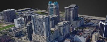
3D modelling and mapping software. DJI Terra will make handling drone data much easier, unlocking the potential of the data that drones are collecting.The photos captured from your DJI drone can now be transformed into digital 3D models or maps. This allows organisations to analyse the data much more easily and accurately. The models created in DJI Terra can be used in a huge array of applications, including public safety, construction, infrastructure, agriculture and media.
Automatic Flight Planning and Data Capture DJI Terra helps commercial drone pilots quickly plan automated flights with several easy-to-use options based on the area or objects they’d like to capture and the type of map or 3D model they’d like to create. It features three mission planning types:
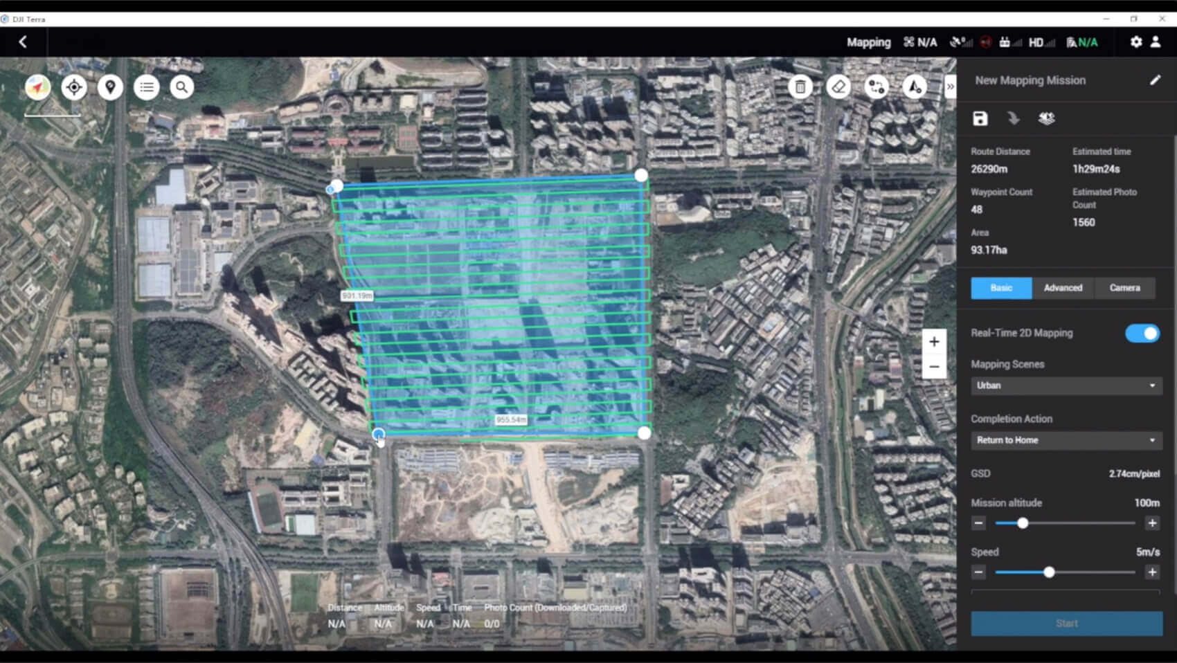
* Area: Capture a specific area quickly and easily by drawing a custom polygonal flight zone on a map. DJI Terra automatically generates efficient flight path options based on the area selected.
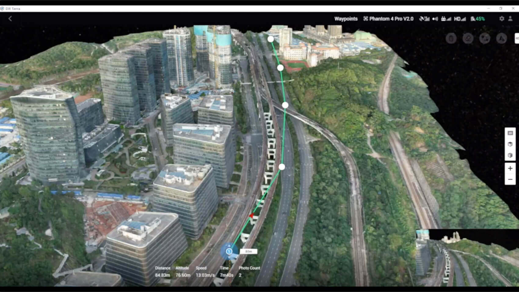
* Waypoint: Create dynamic custom flight paths through an area or around objects using waypoints and adjustable parameters like aircraft altitude, speed, heading, gimbal pitch and angle. For more complex missions that require high attention to detail, the 3D Flight Visualization feature enables the design and simulation of missions on existing 3D models.
* Oblique: Capture a rich data set by automatically flying the same route multiple times. Each flight automatically adjusts the angle of the camera to capture new details, giving an extra crisp 3D model of the object or asset from multiple angles.
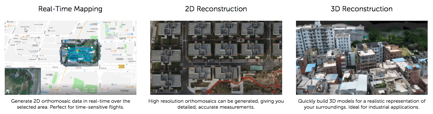
Real-time Mapping and Detailed 3D Models * Real-time mapping: DJI Terra allows drone pilots to quickly generate 2D orthomosaic maps as the drone flies, ideal for time-sensitive missions where situational awareness is critical and decisions need to be made in minutes.
* Fast processing capability for efficient reconstruction: With DJI Terra, users can efficiently generate realistic representations of any environment through detailed 2D orthomosaics and 3D model reconstructions, used for industrial applications like reconstructing vehicle crashes, tracking progress on construction projects or conducting large-scale critical infrastructure inspections on bridges and roadways.
3D Models only available on Terra Pro Version
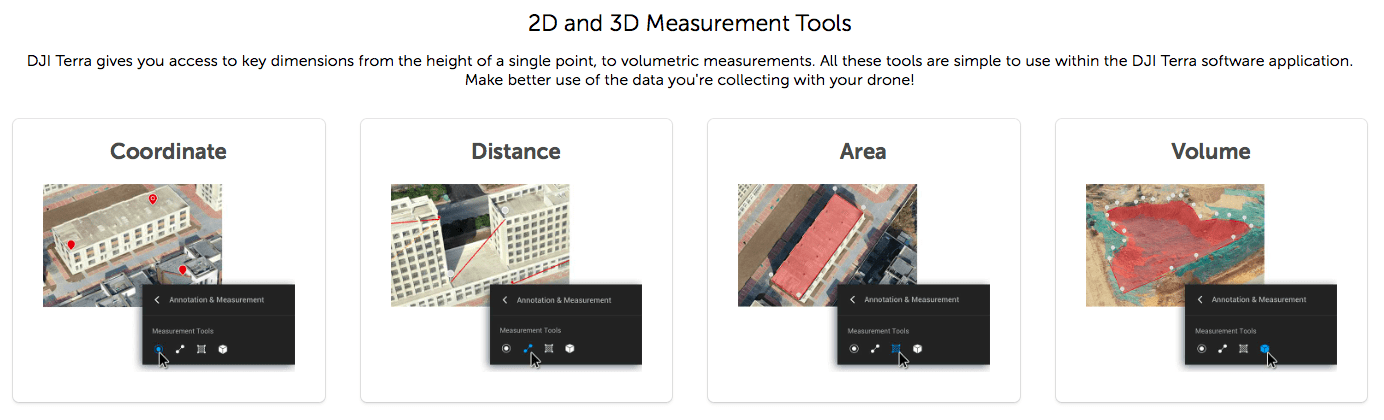
Easy Data Analysis
* 2D and 3D Measurement Tools: analyze data and generate instant insights with easy-to-use analysis tools that provide a variety of measurements including linear distance, surface area and volumetric estimations.
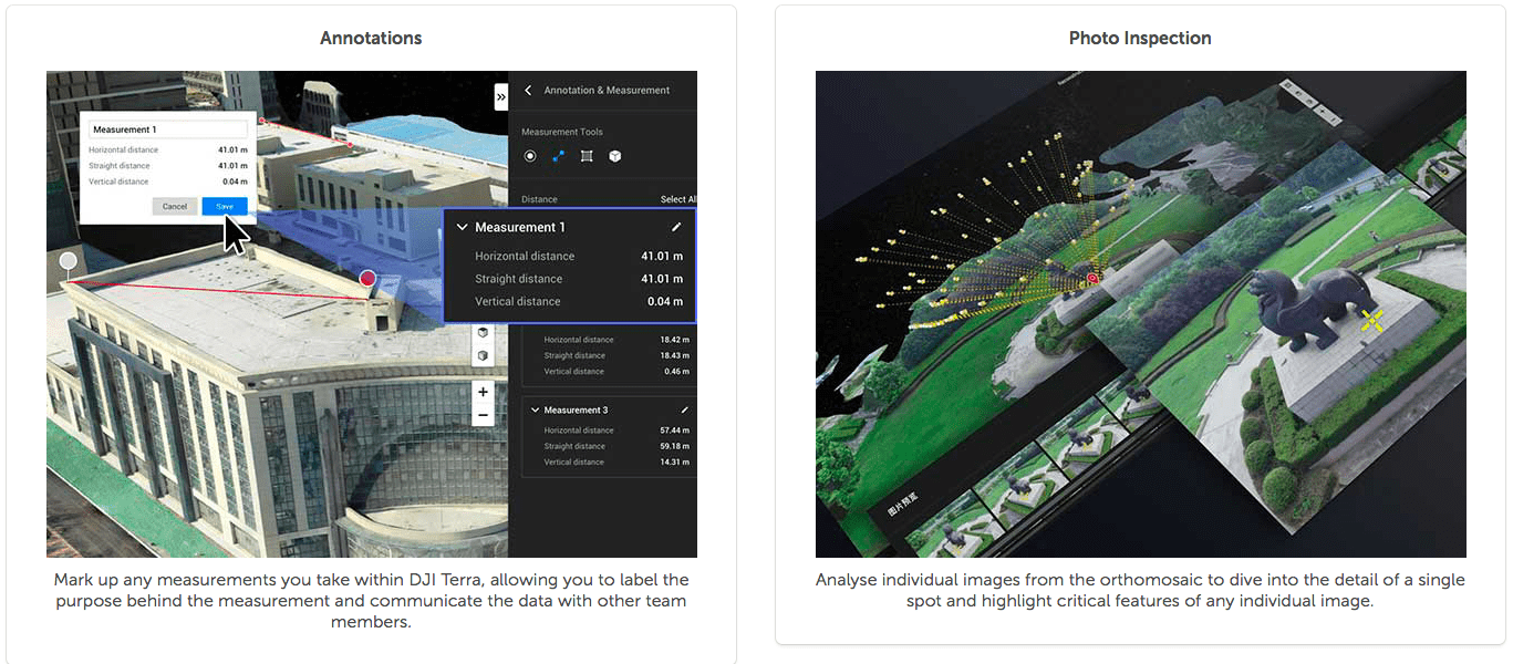
* Annotation: To improve team communication and reporting throughout ongoing projects, annotation labels can be edited and shared.
* Photo Inspection: Ideal for detailed site inspections and accident reconstruction situations, DJI Terra’s photo inspection tool lets users closely examine every photo used to create the model so they can pinpoint and highlight critical elements.
Aircraft Compatibility DJI Terra is compatible with the following Phantom 4 Series drones: Phantom 4 RTK, Phantom 4 Pro V2.0, Phantom 4 Pro + V2.0, Phantom 4 Pro, Phantom 4 Advanced and Phantom 4
Features Realtime 2D Mapping
Agricultural Application
KML File Import
2D Reconstruction Field
2D Reconstruction Urban
3D Reconstruction PRO VERSION ONLY
3D Mission Planning PRO VERSION ONLY
Flight and Aerial Photography
What is the difference between Waypoints Mission, Mapping Mission, and Oblique Mission?
Waypoints Mission: Plan a flight route and capture photos or videos at waypoints along the route.
Mapping Mission: Collect images of an area to reconstruct a 2D model.
Oblique Mission: Collect images of an area from multiple camera angles to reconstruct a 3D model.
Why are there five flight routes when I plan an Oblique Mission in DJI Terra?
DJI Terra’s Oblique Mission uses five flight routes to capture the same amount of data as using five cameras simultaneously on a drone. The five flight routes correspond to the five camera headings – downward, forward, backward, leftward and rightward.
How do I plan flight routes when there is no internet connection and the map cannot be loaded?
If you have access to a mobile device that has an internet connection (such as a cellphone), you can turn on the hotspot so that the laptop can be connected to the internet.
If the site where you are operating has no internet signal, you can pre-plan the flight route while you are indoors and have an internet connection, or manually fly the drone around the area to be mapped to set boundaries points to plan flight routes.
What is Ground Sample Distance (GSD)?
In photogrammetry and remote sensing, ground sample distance (GSD) in an aerial digital photo (such as an orthophoto) of the ground is the actual distance on the ground captured as represented by pixels. The unit is cm/pixel.
In the New Mapping Mission page, what does Relative Height in Advanced Settings mean? How is it different from Mission Altitude in Basic Settings?
Relative Height in Advanced Settings is the height of the takeoff point relative to the area being mapped. Mission Altitude is the height of the drone relative to the area being mapped, which is also how ground sample distance (GSD) is calculated.
When do I have to adjust the Relative Height in Advanced Settings?
When there is a large difference between the elevation of the takeoff location and the elevation of the area being mapped, you can adjust the Relative Height in Advanced Settings to ensure that the Mission Altitude is determined considering the elevation of the area being mapped. For instance, if the drone takes off from a 50m building and the expected altitude for aerial data collection is 100m, you can set the Mission Altitude in Basic Settings to 100m, and Relative Height in Advanced Settings to 50m.
What should I do to ensure accuracy in my missions when collecting data with the Phantom 4 RTK?
1: Conduct your missions in clear weather conditions with high visibility.
2: Check the images and videos for brightness and clarity immediately after your mission.
3: During a surveying mission, avoid areas with strong electromagnetic interference or obstructions to ensure the accuracy of the attitude algorithm of the Phantom 4 RTK. Also make sure that the remote controller is properly linked to the aircraft.
4: Ensure there is enough forward and side overlap. It is recommended to have a forward overlap rate of 80% and a side overlap rate of 70%. Overlap rates can be adjusted depending on the terrain.
When should I adjust the overlap rates based on the terrain?
It is recommended to have a forward overlap rate of 80% and a side overlap rate of 70%, which should meet the requirements for most application scenarios. The overlap rate can be increased when the area being mapped has a large difference in elevation to ensure the highest point mapped has enough overlap. When the area mapped is relatively uniform in elevation, the overlap rate can be adjusted lower to reduce the amount of data that needs to be processed, making the mapping mission more efficient. However, it is recommended to keep the forward overlap at a minimum of 65% and side overlap at a minimum of 60%.
When I connect DJI Terra to Phantom 4 RTK, the app tells me that I cannot take off because the RTK signal is too weak. What should I do?
It could be that you are operating somewhere with a lot of signal interference or obstructions, which affects the strength of the RTK signal. Try turning off the RTK module and take off manually with the GNSS positioning. Once the drone reaches a height where there is less interference, you can turn on the RTK module and connect to DJI Terra to conduct your flight missions.
Does DJI Terra support the marking of Ground Control Points (GCPs)?
Currently, DJI Terra does not support GCPs, but a similar mapping accuracy can be achieved by using DJI Terra with Phantom 4 RTK without marking GCPs.
Building Reconstruction Models
Why is my computer stuck when processing images locally to reconstruct a model? Can I run DJI Terra while running other programmes?
To build reconstruction models as quickly as possible, DJI Terra uses all the computer resources available, including the CPU, RAM, and VRAM of the graphics card, which could make the computer slower while running DJI Terra but should not be a problem once the processing is finished. It is recommended that you don’t run other programmes that might be GPU-intensive while running DJI Terra, as doing so could result in failure of model reconstruction.
What are the Field, Urban, and Fruit Tree Scenarios in 2D Map?
The Field Scenario is designed to capture data from a relatively flat land, for example rice or wheat fields.
The Urban Scenario is designed for areas with buildings of different heights.
The Fruit Tree Scenario is designed for orchards that might have a large variation of elevations and heights. The 2D mapping algorithms are optimized for the three specific scenarios, so you can choose the one that best fits your mission type.
What projection is used to obtain the 2D mapping results in DJI Terra?
The map tiles in DJI Terra use the Web Mercator projection. The digital orthophoto map (result.tif) and digital surface model (dsm.tif) use the Universal Transverse Mercator (UTM) projection, where the projected zone number is calculated by taking the average of longitude coordinates collected.
Why is there a large discrepancy between the elevation result in the digital surface model (DSM) of the 2D map generated by DJI Terra and the actual elevation measured via RTK?
The location information on aerial images collected by a drone that’s not equipped with RTK is not the most accurate, which will result in a difference between the elevation in the digital surface model (DSM) and the actual elevation.
When conducting missions with the Phantom 4 RTK, if the 2D map is generated with only the Nadir view images collected, the precision of the DSM will be limited, which is why it is recommended to incorporate oblique imagery in building the 2D map to enhance precision. This can be done by setting the gimbal pitch to -45° and circling the point of interest during flight.
What is the difference between 3D Reconstruction in Mapping Mission and in Oblique Photography Mission?
There is no difference. If only Nadir view images are available, it is recommended to use a mapping mission for building 2D maps. If oblique photos are available, you can choose an oblique photography mission.
How different are the 3D models built at different resolutions? How long does it take to build models at these resolutions?
There are three options for reconstruction resolution: high, medium, and low, which will generate models at full, half, and quarter resolution respectively. The higher the resolution the better the quality of the reconstructed models. The rough ratio of time consumption for reconstruction at high:medium: low resolutions is about 16:4:1.
Why are there gaps in my model? What are some factors that affect the quality of the reconstruction?
Gaps in the model can be due to missing shots of the area being mapped, or images taken at poor angles. The quality of reconstruction can be affected by factors such as reflective surfaces in the area (water or glass), or large areas of the same colour or pattern (white walls, skies).
Can I trim or edit the 3D models generated in DJI Terra?
Currently this function is not supported. If you would like to edit the model, you can export it and edit in another software.
What files can I get from the 2D maps and 3D models built in DJI Terra?
In addition to the map tiles shown in the app’s interface, DJI Terra’s 2D maps provide digital orthophoto maps and digital surface models in the GeoTIFF format used with UTM projection. DJI Terra’s 3D model reconstructions contain texture mesh in .ply format and level of detail model in .osgb or .b3dm formats.
How do I view the results and files from my 2D maps and 3D models?
You can click the More button in each Mission and open the file folders where the files generated from the missions are stored. You can also use Ctrl + Alt + F to quickly go to the folder. 2D maps are stored under “map” and 3D models are stored under “models”.
To view log files, use Ctrl + Alt + L.
What variables might affect the accuracy of the 2D and 3D reconstructions in DJI Terra?
The accuracy of the reconstruction can be affected by factors such as camera distortion, image quality, flight height, side and forward overlap settings, GPS (RTK) positioning accuracy and the area’s texture information.
What is the accuracy when building 2D maps and 3D models with the Phantom 4 RTK?
When using the Phantom 4 RTK, the absolute accuracy achieved by the 2D maps in DJI Terra is around 1 to 2 times the GSD, which is a similar level of accuracy as other data processing software. When flying at 100m height, the absolute horizontal accuracy of the 2D map is 2-5cm, and the absolute accuracy of the 3D models is within 4cm.
Which coordinate system and elevation are used for 2D and 3D reconstructions in DJI Terra?
The coordinate system used depends on the location of data collection. When using the Phantom 4 RTK to collect data, you can choose the coordinate system of the RTK module on the remote controller from the China Geodetic Coordinate System 2000 (CGCS2000), the World Geodetic System 1984 (WGS84, which is the default system), or a custom coordinate system. If you use another drone, the images collected have coordinates from the WGS84 system. The elevation of the data collected with the CGCS2000 and WGS84 system is the ellipsoid height.
Can I run multiple missions on the same computer?
Currently you cannot run multiple missions due to limitations in the computer’s processing capacity.
Other
Can I import models generated in DJI Terra into other software programs, such as Maya, Blender, SketchUp and 3ds Max?
When you convert .ply files generated in DJI Terra into .obj files, you can import them into Maya, Blender, SketchUp, and 3ds Max. Look up tutorials for the specific process for each software.
Can I embed a 3D model into a webpage?
Yes, .b3dm, .osgb, and .ply files generated by DJI Terra are universal file formats and can be embedded into webpages. You can find instructions for embedding each of these formats online.
Can I use non-aerial images to build 2D or 3D models?
Theoretically they can be used to reconstruct 3D models although the quality might suffer. They cannot be used to build 2D reconstructions.
Can I process images taken from non-DJI drones in DJI Terra to build 2D and 3D reconstructions?
Theoretically yes for 3D models, but the results might not be as good as if you were to use DJI drones. The quality of the reconstructions will benefit from GPS or RTK positioning data on the images. 2D reconstructions are not supported.
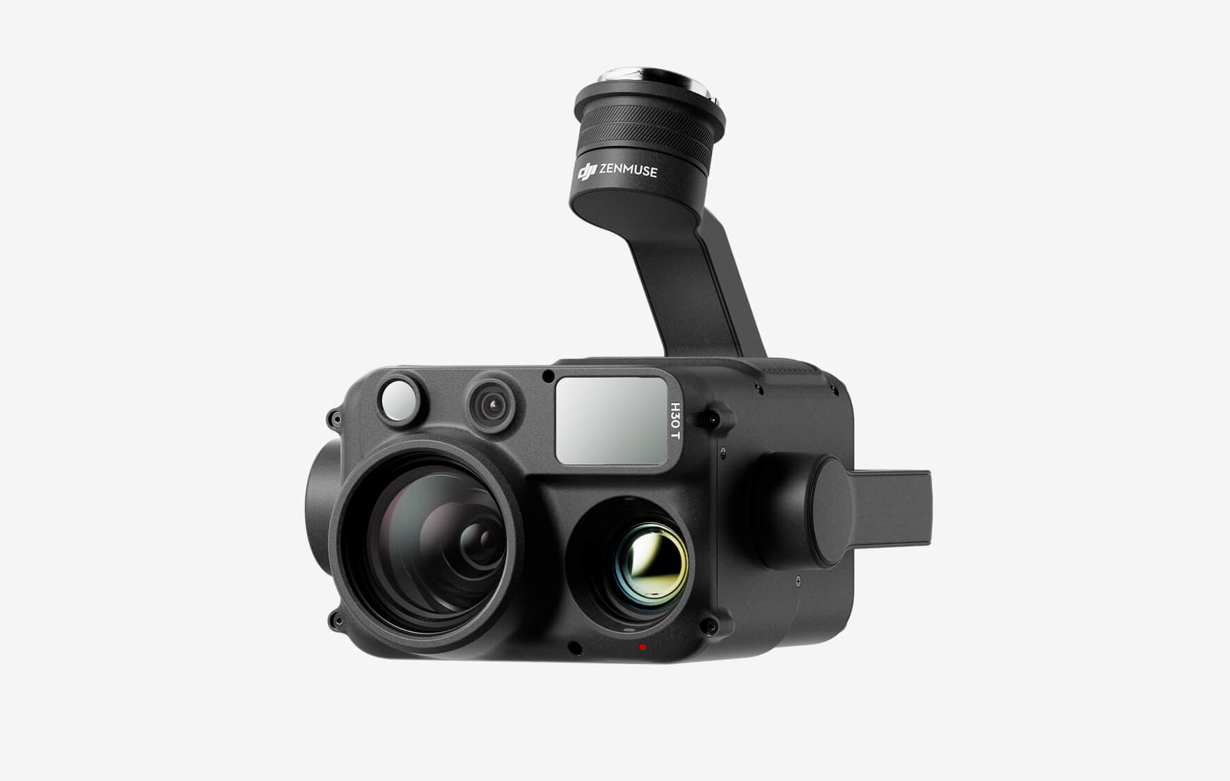
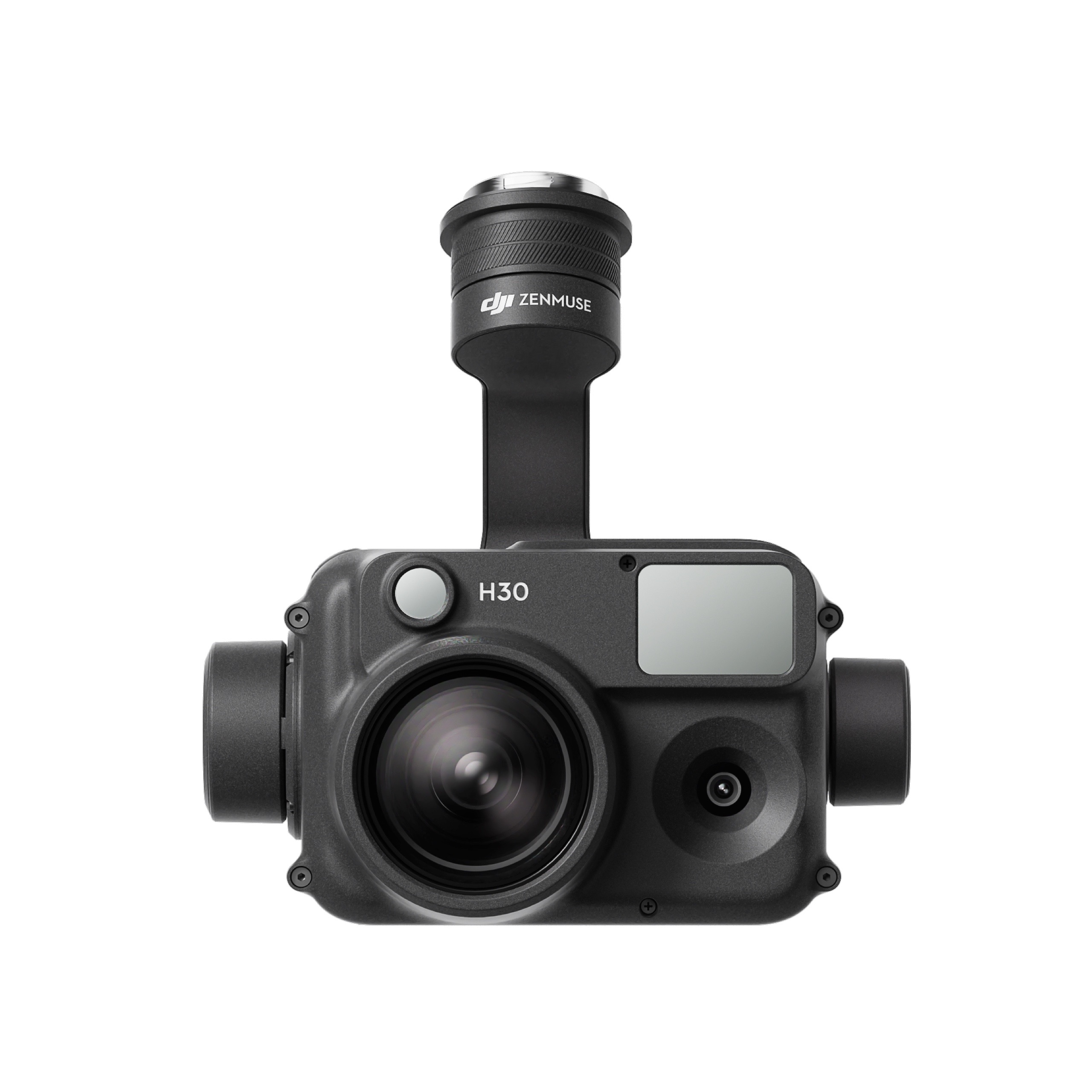
The all-weather, multi-sensor flagship Zenmuse H30 Series integrates five major modules—a wide-angle camera, a zoom camera, an infrared thermal camera, a laser range finder, and an NIR auxiliary light. Employing cutting-edge intelligent algorithms, it revolutionizes perception and imaging standards, transcending the limitations of day and night vision. This makes it effortlessly suitable for a variety of operations, including public safety, energy inspection, water conservation, and forestry.
The all-weather, multi-sensor flagship Zenmuse H30 Series integrates five major modules—a wide-angle camera, a zoom camera, an infrared thermal camera, a laser range finder, and an NIR auxiliary light. Employing cutting-edge intelligent algorithms, it revolutionizes perception and imaging standards, transcending the limitations of day and night vision. This makes it effortlessly suitable for a variety of operations, including public safety, energy inspection, water conservation, and forestry.
This website uses cookies so that we can provide you with the best user experience possible. Cookie information is stored in your browser and performs functions such as recognising you when you return to our website and helping our team to understand which sections of the website you find most interesting and useful.
Strictly Necessary Cookies
Strictly Necessary Cookie should be enabled at all times so that we can save your preferences for cookie settings.
If you disable this cookie, we will not be able to save your preferences. This means that every time you visit this website you will need to enable or disable cookies again.
3rd Party Cookies
This website uses Google Analytics to collect anonymous information such as the number of visitors to the site, and the most popular pages.
Keeping this cookie enabled helps us to improve our website.
Please enable Strictly Necessary Cookies first so that we can save your preferences!
Additional Cookies
This website uses the following additional cookies:
(List the cookies that you are using on the website here.)
Please enable Strictly Necessary Cookies first so that we can save your preferences!

There are no reviews yet.