DJI D-RTK Ground System Kit with DATALINK PRO 900

  • For UAVs with DJI A3 Flight Controllers
  • Works with DJI Matrice 600
  • Provides Centimeter-Level Precision
  • GPS + GLONASS Navigation Access

Categories ,

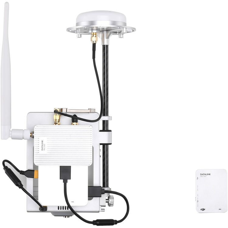
If you’re utilizing a drone for commercial, industrial, or scientific purposes, and precision is a top priority, then you may need the D-RTK GNSS with DATALINK PRO 900 from DJI. Designed for drones that use A3 flight controllers, such as the Matrice 600, this navigation and positioning system comprises three D-RTK antennas, a DATALINK PRO 900 base station, a mobile station, and all of the hardware needed to mount the D-RTK antennas and mobile station to your UAV.


The system passes signals between the base and mobile stations via the A3 flight controller during flight, and utilize the D-RTK antennas to access GPS + GLONASS via a dual-positioning module for centimeter-level, precision 3D positioning, enhanced altitude accuracy, and a true heading that is resistant to magnetic interference. For additional flight management, drone calibration, and more, D-RTK supports both the DJI GO and Assistant 2 apps.


DATALINK PRO
This wireless datalink supports the A3 flight controller and D-RTK antennas to provide Full Duplex or Broadcast transmission modes to your UAV. In Full Duplex Mode, the base and mobile station conduct two-way communication, but in Broadcast Mode, data is only sent from base station to mobile station, with the ability to transmit to up to 32 different UAVs with mobile stations attached to them. If your craft is highly customized, DATALINK PRO supports a range of ports if needed, such as USB, CAN, and UART. Ports can be individually selected by toggling a switch, and data is automatically transmitted from one to another
Precision Positioning
Precise positioning of one centimeter vertically and horizontally is made possible through dynamic differential technology. This extreme accuracy allows for the creation of repeatable flight routes that provide reliable and valuable visual data that can be essential for commercial and industrial scenarios.
Altitude Accuracy
Barometers commonly found in UAS systems may suffer from altitude discrepancies when faced with fluctuations in airflow, such as during takeoff, under braking, or after extended flying. This affects an aircraft’s flight, and introduces unwanted data variation that complicates workflows. D-RTK’s precision altitudinal calculations reduce variation to one centimeter, effectively eliminating variations, giving you data that you can rely on.
True Heading
Dual antennas create heading references that are significantly more accurate than possible with a single compass sensor. By removing compass dependence, the system is also resistant to magnetic interference, such as those generated by metal structures and high voltage power lines, allowing for accurate flight in environments where other aircraft cannot function.
Categories: ,

Based on 0 reviews

0.0 overall
0
0
0
0
0

Be the first to review “DJI D-RTK Ground System Kit with DATALINK PRO 900”

There are no reviews yet.

Matrice 350 RTK

An upgraded flagship drone platform, the Matrice 350 RTK sets a new benchmark for the industry. This next-generation drone platform features an all-new video transmission system and control experience, a more efficient battery system, and more comprehensive safety features, as well as robust payload and expansion capabilities. It is fully powered to inject innovative strength into any aerial operation.

Buy
GPR system: Radar Systems Zond Aero LF (low frequency)

Extra-lightweight GPR system, suitable for medium-sized drones like DJI M300 RTK.

Comes with 3x sets of dipoles for the 300, 150, and 100 MHz.

Utilizes Real Time Sampling (RTS) with high hardware stacking, delivering high-resolution low-noise data.

Buy
Laser Falcon methane detector

Laser Falcon is sensitive only to methane, so no false readings of other gases are possible. It is a class 3R eye-safe laser.

The concept is based on Infrared Absorption Spectroscopy. The laser emits light (spectral range of 1,65 μm), which reflects back and is captured by the sensor. The outgoing and incoming signals are compared with the built-in reference cell. If methane is present along the laser path, the laser light is partially absorbed. An algorithm calculates the gas concentration in ppm×m (parts per million multiplied by meter). The value is instantly transferred to the remote control (RC) of the drone pilot and to UgCS software.

Buy

Inquire price for

    ×