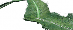
Processing of various types of imagery: aerial (nadir, oblique) & close-range.
Auto calibration: frame (incl. fisheye), spherical & cylindrical cameras.
Multi camera projects support.
Elaborate model editing for accurate results.
.LAS export to benefit from classical point data processing workflow.
Various scenes: archaeological sites, artifacts, buildings, interiors, people, etc.
Direct upload Sketchfab resource and export to varios popular formats.
Photorealistic textures: HDR and multifile support.
3D reconstruction for data captured from the same camera position — camera station, provided that at least 2 camera stations are present.
360° panorama stitching for one camera station data.
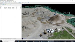
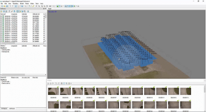
Agisoft Metashape is a stand-alone software product that performs photogrammetric processing of digital images and generates 3D spatial data to be used in GIS applications, cultural heritage documentation, and visual effects production as well as for indirect measurements of objects of various scales.
Wisely implemented digital photogrammetry technique enforced with computer vision methods results in smart automated processing system that, on the one hand, can be managed by a new-comer in the field of photogrammetry, yet, on the other hand, has a lot to offer to a specialist who can adjust the workflow to numerous specific tasks and different types of data. Throughout various case studies Metashape proves to produce quality and accurate results.
Features (Professional)
Photogrammetric triangulation
Processing of various types of imagery: aerial (nadir, oblique) & close-range.
Auto calibration: frame (incl. fisheye), spherical & cylindrical cameras.
Multi camera projects support.
Dense point cloud: editing and classification
Elaborate model editing for accurate results.
Points classification to customize geometry reconstruction.
.LAS export to benefit from classical point data processing workflow.
Digital elevation model: DSM/DTM export
Digital Surface and/or Digital Terrain Model – depending on the project.
Georeferncing based on EXIF meta data/flight log: GPS/GCPs data.
EPSG registry coordinate systems support: WGS84, UTM, etc.
Georeferenced orthomosaic export
Georeferenced orthomosaic: most-GIS-compatible GeoTIFF format; .KML file to be located on Google Earth.
Export in blocks for huge projects.
Color correction for homogeneous texture.
Measurements: distances, areas, volumes
Inbuilt tools to measure distances, areas and volumes.
To perform more sophisticated metric analysis Metashape products can be smoothly transferred to external tools thanks to a variety of export formats.
Ground control points: high accuracy surveying
GCPs import to control accuracy of the results.
Coded/non-coded targets auto detection for fast GCPs input.
Scale bar tool to set reference distance without implementation of positioning equipment.
Python scripts: customize processing workflow
In addition to Batch processing – a way to save on human intervention, Python scripting suggests customization options: a parameters template for several similar data sets; intermediate processing results inspection; etc.
Multispectral imagery processing
RGB/NIR/thermal/multispectral imagery processing.
Fast reconstruction based on preferable channel.
Multichannel orthomosaic generation for built-in vegetation indices (NDVI) calculation and export.
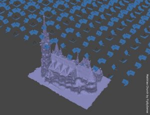
3D model: generation and texturing
Various scenes: archaeological sites, artifacts, buildings, interiors, people, etc.
Direct upload Sketchfab resource and export to various popular formats.
Photorealistic textures: HDR and multifile support.
4D modeling for dynamic scenes
Multi camera station data processing for creative projects in cinemato- graphic art, game industry, etc.
Basis for numerous visual effects with 3D models reconstructed in time sequence.
Panorama stitching
3D reconstruction for data captured from the same camera position – camera station, provided that at least 2 camera stations are present.
360° panorama stitching for one camera station data.
Network processing
Distributed calculations over a computer network to use combined power of multiple nodes for huge data sets processing in one project.
Agisoft Metashape is an advanced image-based 3D modeling solution for creating professional quality 3D content from still images. Based on the latest multi-view 3D reconstruction technology, it operates on arbitrary images and is efficient in both controlled and uncontrolled conditions. The photos can be taken from any positions, providing that an object to be reconstructed is visible on at least two photos. Both image alignment and 3D model reconstruction is fully automated.
All purchases of Agisoft Metashape include a “Quick Start Guide” valued at $400. The quick start guide is intended to get you up and running quickly with a high accuracy workflow – including Ground Control Points.
Stand-Alone license is a rehostable node-locked license, i.e. one license allows to activate the program at one machine only, however, the license can be transferred to a different computer if needed. Stand-Alone license allows to use Metashape software in all kinds of paid and unpaid projects. The license is available both to individuals and legal entities, such as companies, firms, museums, reseach institutions, governmental institutions, etc.
Floating license allows to install the program on as many computers as desired and run it, at any one time, on as many systems as the number of licenses purchased indicates. One computing machine shall be designated as the “license server”; the license server utility installed on it will manage license distribution across the network of computers where the program has been installed. Floating license is available for Agisoft Metashape Professional Edition only.
Educational licenses (rehostable node-locked) and Educational Floating licenses are available exclusively to accredited educational institutions, their employees and students of such institutions. Only officially accredited educational institutions are eligible to obtain Agisoft Metashape educational licenses. This includes: universities, colleges, junior colleges, scientific and technical schools, vocational schools, and correspondence schools. Educational or Educational Floating licenses can also be purchased by students and officially employed teaching and research staff of officially accredited educational institutions.
Any educational license prohibits all commercial uses of the software. Educational / Educational Floating and Stand-Alone / Floating licenses differ legally but are technically identical.
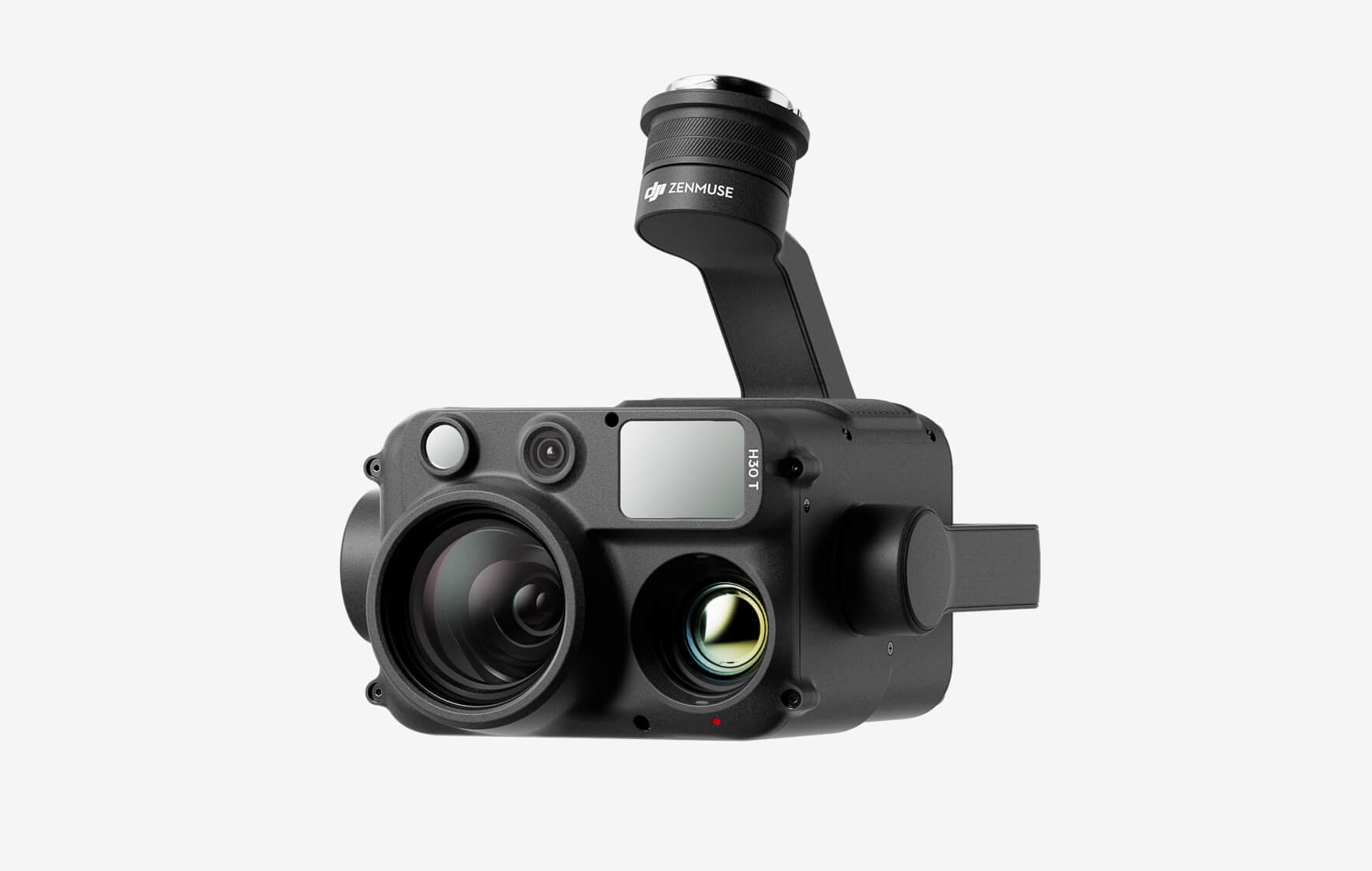
The all-weather, multi-sensor flagship Zenmuse H30 Series integrates five major modules—a wide-angle camera, a zoom camera, an infrared thermal camera, a laser range finder, and an NIR auxiliary light. Employing cutting-edge intelligent algorithms, it revolutionizes perception and imaging standards, transcending the limitations of day and night vision. This makes it effortlessly suitable for a variety of operations, including public safety, energy inspection, water conservation, and forestry.
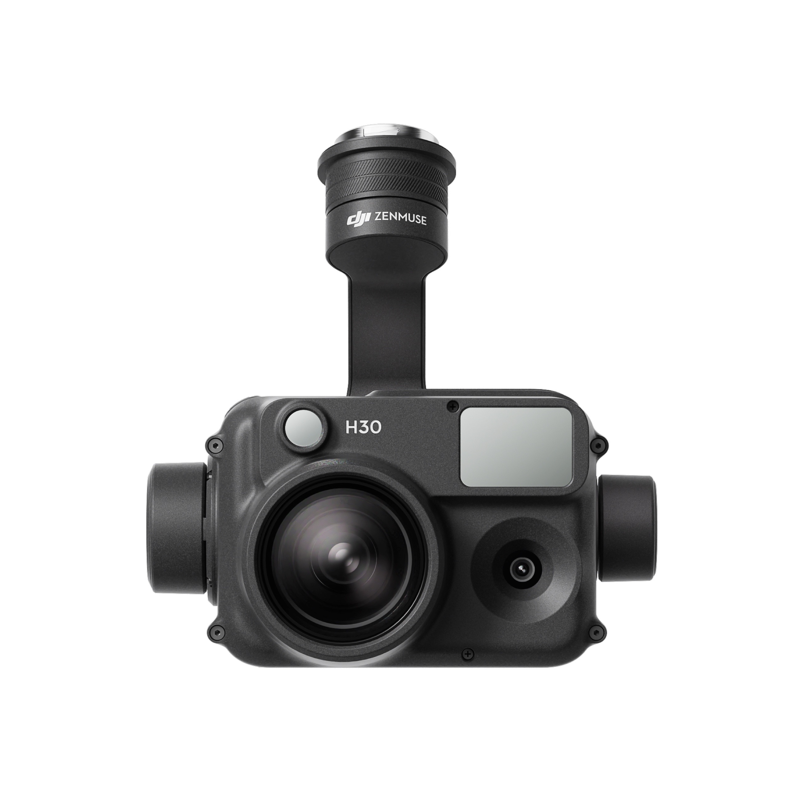
The all-weather, multi-sensor flagship Zenmuse H30 Series integrates five major modules—a wide-angle camera, a zoom camera, an infrared thermal camera, a laser range finder, and an NIR auxiliary light. Employing cutting-edge intelligent algorithms, it revolutionizes perception and imaging standards, transcending the limitations of day and night vision. This makes it effortlessly suitable for a variety of operations, including public safety, energy inspection, water conservation, and forestry.
This website uses cookies so that we can provide you with the best user experience possible. Cookie information is stored in your browser and performs functions such as recognising you when you return to our website and helping our team to understand which sections of the website you find most interesting and useful.
Strictly Necessary Cookies
Strictly Necessary Cookie should be enabled at all times so that we can save your preferences for cookie settings.
If you disable this cookie, we will not be able to save your preferences. This means that every time you visit this website you will need to enable or disable cookies again.
3rd Party Cookies
This website uses Google Analytics to collect anonymous information such as the number of visitors to the site, and the most popular pages.
Keeping this cookie enabled helps us to improve our website.
Please enable Strictly Necessary Cookies first so that we can save your preferences!
Additional Cookies
This website uses the following additional cookies:
(List the cookies that you are using on the website here.)
Please enable Strictly Necessary Cookies first so that we can save your preferences!