
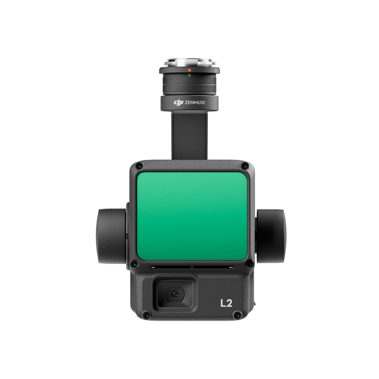
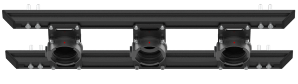
- High Precision
- Exceptional Efficiency
- Superior Penetration
- 250m/450m Detection Range
- 5 Returns
- Turnkey Solution
- Point Cloud LiveView
- One-Click Processing on DJI Terra
No products in the cart.
In UgCS there are multiple different flight modes. Manual flight mode allows you to control the drone as you are used to – with the RC remote. Once you have created a flight plan and uploaded it to the drone you will be able to use the Automatic flight mode, allowing you to send the drone on the mission. For many drones UgCS also supports Click & Go and Joystick control flight modes. Read more about these further down.
Automated drone mission planning, built-in photogrammetry and geotagging tools, map customisation and battery exchange option for long routes make UgCS an effective solution for wide range of applications.
UgCS comes with multiple in-built tools to make aerial surveys and mapping as easy and effortless as possible. Choose one of the pre-installed camera pre-sets or create a new one to suit your camera. The area scan mission will be calculated automatically based on the settings of your camera. Alternatively you are able to manually enter all the area scan parameters such as overlap and desired altitude.
At UgCS we know that battery is a limiting factor for automated flights. This is why UgCS enables the feature to upload routes partially to drones, to fly longer routes with the possibility to stop the mission, exchange the battery of the drone and then continue the flight from where you left off. This feature depends on drone type.
UgCS features mission planner with a Google Earth-like 3D interface for mission planning for drones. This allows you to navigate the environment around you more easily. Moreover, a 3D mission planning environment gives you more control by allowing you to view the created flight plan from all angles, taking into account any obstacles such as terrain or buildings.
UgCS enables to download 3D globe with terrain elevation data. To download the data from server, internet connection is required. By knowing the exact altitudes above sea level at all points you will be able to plan your missions with respect to the surroundings. After the calculation of each flight plan you are able to see an elevation profile and the altitude above ground and sea level where the drone will be at each point.
Pilots would not be able to fly airplanes or helicopters without the dashboard. Drones should be no exception. UgCS gives you an in-flight display of all the telemetry data you are interested in the telemetry data window. This includes the battery level, radio link and GPS signal quality, current course and heading, speed, altitude and much more.
In UgCS there are multiple different flight modes. Manual flight mode allows you to control the drone as you are used to – with the RC remote. Once you have created a flight plan and uploaded it to the drone you will be able to use the Automatic flight mode, allowing you to send the drone on the mission. For many drones UgCS also supports Click & Go and Joystick control flight modes. Read more about these further down.
In UgCS the Click & Go flight mode is supported for most drones. In cases when RC control is not optimal, but you need the drone to go someplace fast, this is the best solution. Simply click on the map where you want the drone to go, enter a desired altitude and it will fly to the desired location.
Feel like flying your drone from your laptop instead of the RC remote? We’ve got you covered. UgCS supports the Joystick flight mode. This allows you to plug in a joystick into your laptop and then control the drone through the telemetry link. Not only is this more exciting than the RC remote, it also gives you more intuitive control over the drone.
There are in-built software emulators in UgCS for fixed wing and rotary wing drones – emuplane and emucopter. If you don’t have a drone with you or just want to test out a route before uploading it to a real drone the emulators can help. Feel free to play around with them to discover the exciting new features of UgCS in a safe environment.
UgCS comes with an in-build geotagging tool. This tool allows you to sync the timestamps of the images with the telemetry data recorded during the flight. After placing the geotags with coordinates and correct altitudes on the images you can process them in software such as Pix4D or similar to create map overlays or 3D models.
All the telemetry data from your flights is recorded in UgCS. With UgCS you are able to replay your flights. The telemetry player is not only able to replay the telemetry data from your drone, it also allows you to replay the video recorded by the drone during the flight.
UgCS allows you to import the models of 3D buildings. This allows UgCS to automatically calculate the flights around the buildings by taking into the account the desired pre-set distance to objects. The amount of buildings which can be imported is 20 in UgCS OPEN, 100 in UgCS ONE version and an unlimited amount of buildings in the UgCS PRO and UgCS ENTERPRISE.
KML data import allows operator to import placemarks to denote important places on the map. KML stands for Keyhole Markup Language.
DEM stands for Digital Elevation Models. The terrain is always changing. These changes are not always implemented into 3D maps as fast as it is needed. An example would be a quarry. If the operator of a UAV would want to fly an automated mission for the purposes of mapping, surveying or monitoring a quarry, he would need to import DEM data to fly below what would otherwise be considered ground level. This data would then make the drone able to fly closer to the ground in the quarry to do its mission. Another scenario is in mountains where operator needs to use DEM with more precise data as commonly available map providers use too few elevation points on their maps to plan safe missions. This feature is available for users of UgCS PRO and UgCS ENTERPRISE.
When flying automated missions with drones, precise maps are more important than ever. In UgCS it is possible to import geotiff images as map overlays. This gives you the power to customise the UgCS map to suit your needs.
UgCS has built-in No-Fly zones (NFZ) for all major airports, enabling a safe flight planning near airports since the flight path will automatically be calculated around the no-fly zone. Airport no-fly zones can be disabled in UgCS PRO and UgCS ENTERPRISE.
The option to create own custom no-fly zones (NFZ) is available for all UgCS Licence types, except UgCS OPEN, enabling to specify regions where flights are prohibited. UgCS will automatically calculate flight path around these areas and make sure that the drone does not enter NFZ while on an automated flight.
In UgCS it is enabled to set boundaries for the flights starting from the first waypoint. This allows you to make sure that the drone does not fly too far away or higher than desired and allowed by local laws. In UgCS OPEN the default restriction for flights is 500m from the first waypoint and 120m AGL. In UgCS ONE, UgCS PRO and UgCS ENTERPRISE these restrictions can be removed and set any desired values.
Pilots would not be able to fly airplanes or helicopters without the dashboard. Drones should be no exception. UgCS gives you an in-flight display of all the telemetry data you are interested in the telemetry data window. This includes the battery level, radio link and GPS signal quality, current course and heading, speed, altitude and much more.
UgCS is compatible with ADS-B receivers such as microadsb.com. This means that you can bring an ADS-B receiver into the field, connect it to your laptop and once it’s recognized UgCS will warn you of any aircraft approaching your drone. This feature is available for users of UgCS ONE, UgCS PRO and UgCS ENTERPRISE.
Here at UgCS we have experience with setting up ADS-B transponders / transmitters to work with small drones. Parameters such as Flight ID and Squawk code can be set via UgCS. This feature is available only to the users of UgCS ENTERPRISE.
In UgCS you are able to not only display the video feed coming from your drone, but also record it. This recording can then be replayed later on in the telemetry player. It is available for the users of UgCS One and Pro.
Camera footprint option can be enabled for drones in UgCS, allowing you to see the area seen by the camera lens in real time. Depending on drone type additional configuration could be necessary. This feature is useful for industrial monitoring, agriculture and has many other applications. It is available for all UgCS user, except UgCS OPEN.
UgCS software has a modular design, meaning that different parts of the software can run on different machines. UgCS consists of the server, the client and VSMs (vehicle specific modules). This structure allows you to have a central ground station monitoring the work of multiple operators in the field.
Because of the modular design of UgCS, it is possible to not only use multiple drones connected to the same computer, but also multiple computers connected to a main ground station. This allows you to have multiple operators of drones, each being monitored by the central ground station giving the directions.
With UgCS you are able to use multiple drones at the same time. More over, these drones do not have to be from the same manufacturer since UgCS supports many different autopilots.
UgCS provides convenient tools for areal or linear surveys and direct drone control. Feature set suites for organisations of different scale: from single professional operator to large enterprise with dedicated UAV department.
UgCS software has a modular design, meaning that different parts of the software can run on different machines. UgCS consists of the server, the client and VSMs (vehicle specific modules). This structure allows you to have a central ground station monitoring the work of multiple operators in the field.
UgCS allows planning longer routes which, in turn, allows covering a larger distance of powerlines. Larger mission can be interrupted to change the battery or do other adjustments and can be restarted from place of interruption. Furthermore, UgCS allows triggering the camera only when required, thus reducing the total number of images and the time needed for data analysis.
In UgCS it is possible to use Circle missions, which make the drone automatically fly around a certain point while facing towards it. This can be used together with video recording to film the tower from all positions. Similarly as with photographs, video recording can be started and stopped from UgCS interface, thus reducing the total length of the video, which in turn is less likely to fill up the memory card of the camera.
In UgCS the operator gets access to many special camera actions allowing to either trigger the camera on the drone by time (every X seconds) or by distance (every X meters). This is an essential tool for continuous photography and high quality 2D or 3D model generations. Also, with UgCS it is possible to plan missions at a certain altitude above sea level (AMSL). This can greatly increase the quality of 3D generated models. In UgCS all of video recorded is referenced with telemetry, allowing the operator to see exactly where the drone was while filming it.
Finally, UgCS is not only capable of controlling drones equipped with photo and video cameras, it is also capable of controlling drones equipped with LIDAR.
To get the images for vegetation indexes, a drone with a camera needs to be sent on an automatic flight over the field. Doing this in manual mode is not possible since the locations have to be precise.
UgCS comes with an built-in Photogrammetry tool which makes aerial surveying an ease. Simply by marking down the field which needs to be scanned on the map and entering a desired ground sample distance (GSD) and a desired image overlap, the flight path is automatically calculated. Then the drone can be sent on an automated mission to collect images for later analysis.
With UgCS it is possible to scan large areas since it allows the drone to return when a battery needs to be changed and then fly back and start from the previous waypoint.
UgCS also features a geotagging tool allowing the aerial images made to be synced with telemetry data. Using special photogrammetry tools like Pix4D or Photoscan, the images can be stitched together and NDVI indexes can be calculated.
UgCS comes out-of-the-box with a simple and easy to use interface. At the same time UgCS features multi-drone and multi-operator support. This means that a fleet of drones can be operated, each drone tied to one operator with a laptop in the field. These computers can be connected together and all of the drones and their actions can be monitored on a map at a central command station. Furthermore, all of the flight data is recorded and stored locally, allowing any flight to be replayed together with the video feed from the drone.
This can be used either when operating a large fleet of drones for delivering medicine or just as well when working in search and rescue operations.
Essential, especially for natural disasters is UgCS capability to use custom or even user generated maps. As environment often changes during flooding or after earthquakes as example.
What’s more, the drones can be sent on automatic scanning mission, all while sending the video feedback. This would essentially give the operator live aerial video from various locations of the scene on the central command station and ability to mark points of interest on map for closer examination by ground teams or other drones.
Progress is exciting. While the progress of a construction site might be hard to capture in images, drones can make this possible. For example, by using UgCS a drone can be made to fly to a specific location every day and take a picture. These pictures can then be combined into beautiful timelapses.
Furthermore, it is also possible to create 3D models this way. UgCS comes with an in-built image geotagging tool which allows adding the coordinates to images taken while flying with UgCS, so that they can be processed into 3D representations of buildings and to show progress of construction visually. Furthermore, these 3D buildings can be imported into UgCS for mission planning around them.
Another way to use UgCS is for taking pictures from windows that do not yet exist. The view from windows is very important to people considering buying apartments. To get buyers on-board in time, drones can be used to take pictures at the exact places and orientations where windows of apartments will be.
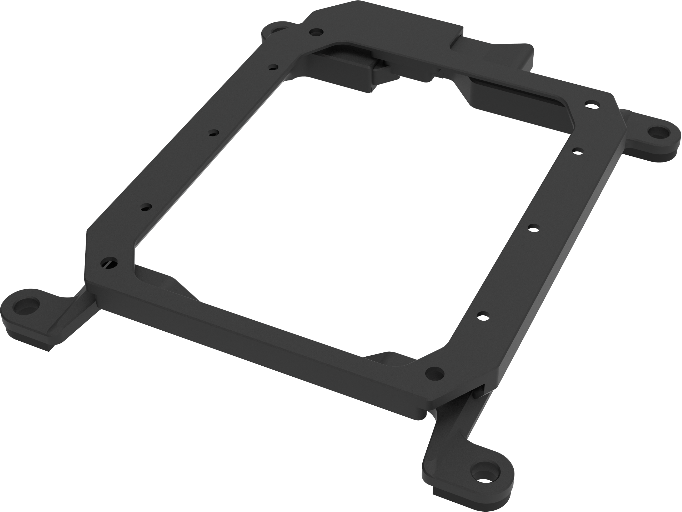
The PSDK load can be fixed to the M30 series flight platform, and different types of PSDK loads can be quickly removed and replaced.
The PSDK load can be fixed to the M30 series flight platform, and different types of PSDK loads can be quickly removed and replaced.
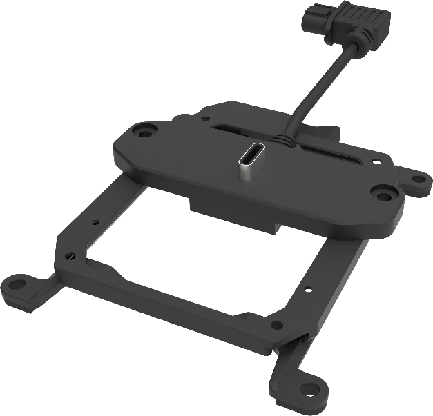
The PSDK load can be fixed to the warp and weft M350 RTK flight platform, and different types of PSDK loads can be quickly removed and replaced.
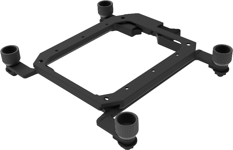
The FC30 EQUIPPED WITH A THREE-LOAD SUPPORT is designed for the DJI FlyCart 30 carrier and can support up to three ET4 FOUR DROP KIT at the same time, achieving 12-stage drops with a maximum payload of 120kg.
This website uses cookies so that we can provide you with the best user experience possible. Cookie information is stored in your browser and performs functions such as recognising you when you return to our website and helping our team to understand which sections of the website you find most interesting and useful.
Strictly Necessary Cookie should be enabled at all times so that we can save your preferences for cookie settings.
If you disable this cookie, we will not be able to save your preferences. This means that every time you visit this website you will need to enable or disable cookies again.
This website uses Google Analytics to collect anonymous information such as the number of visitors to the site, and the most popular pages.
Keeping this cookie enabled helps us to improve our website.
Please enable Strictly Necessary Cookies first so that we can save your preferences!
This website uses the following additional cookies:
(List the cookies that you are using on the website here.)
Please enable Strictly Necessary Cookies first so that we can save your preferences!
More information about our Cookie Policy